


31 Jul The Hill of Tara
“Here sat in days of yore kings with golden crowns upon their heads; warriors with brazen swords in their hands; bards and minstrels with their harps; grey-bearded ollamhs; druids with their oak-leaf crowns; learned historians; wise brehons and subtle lawyers; the physicians; the smiths, artificers, charioteers, huntsmen…Sneer not at the Irishman’s veneration for this spot; the history of its ‘long-faded glories’ is still preserved; the memories of Tara have remained a silver thread in the garment of sackcloth he has worn for centuries.” 1 (Sir William Wilde, 1849)
“…the symbolic dimension of Tara rapidly achieved monumental proportions, to the extent that it has for a long time overshadowed…the real monuments. The myths and legends about Tara have done this too. Being more colourful and attractive they are more amenable than archaeological facts to being woven into the current belief systems of Neo-Celts. But this has probably always been the case: at the heart of religion is myth.” 2 (Conor Newman, 2009)
Click the image above to enter the virtual-reality tour.
In the 160 years between William Wilde’s and Conor Newman’s ruminations on Tara, much has changed. The florid descriptions of royal Tara contained in the ancient texts, which were once considered “a window on the Iron Age,”3 are now understood as the musings of early-medieval monks, “dressing up contemporary issues and contexts in ancient forms.”4 But there is another, perhaps more significant aspect to this green hill: Tara has for generations served as the geographic focus for an aspirational sense of national glory, “the most consecrated spot in Ireland,”5 where blood was shed and where royal (and later political) fortunes were won and lost.
On this page we will describe each of the key monuments on the Hill of Tara. Click to jump to Ráth Gráinne; The Sloping Trenches; The Banquet Hall; The Ditched Pit Circle; The Rath of the Synods; The Churchyard; Ráith na Ríg; The Mound of the Hostages; The Forrad; The Lia Fáil; Tech Cormaic; Ráith Laoghaire; Rath Maeve; Other Monuments; and The Battle of the Motorway.
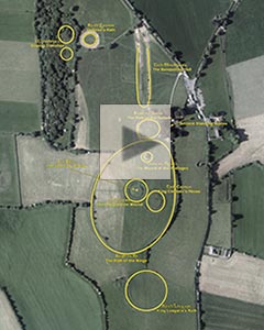
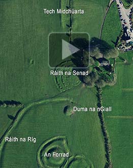
Click to see the visible Tara sites in an annotated satellite view. Press the "I" button to cycle the view.
Putting aside all the bleary-eyed late-night renditions of “The Harp that Once through Tara’s Halls” (listen, below),6 there is something profound and eternally grounded here, on this ancient hill with its 4000 years as a pagan ritual complex, where “the monuments have…become hidden beneath a deep stratigraphy of oral and literary accretions.”7
The Hill of Tara has been sanctified (and occasionally desecrated) since before the oldest of its more than 30 visible features, the Mound of the Hostages (Duma na nGiall), was constructed during the Neolithic era.8 It was sanctified as each generation added its own layers of new construction, as well as layers of symbolic association. The new structures demonstrated the political strengths of their builders, bolstered by the proximity and implied collaboration with the now-mythic ancestral spirits of the Hill of Tara. Combining the mythic with the historical, as many as 142 different rulers may have reigned under the kingship of Tara.9
“This fabulous enfolding: earthworks and stones, the artefacts and associations, lineage and mythography, voices of bards and saints, British Israelites and archaeologists. What is to be made of this evocation?” 10 (Michael Shanks)
In the historic era, Tara served as the bloody last stand for 400 United Irishmen who fell in the 1798 Battle of Tara Hill. Nearly half a century later, perhaps a million citizens took to the hill following Daniel O’Connell’s call for a “Monster Meeting” to rally against the Union with Great Britain.
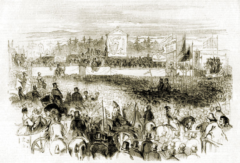
Daniel O’Connell’s ‘Monster Meeting’ at Tara, 15 August, 1843.
Tara was first desecrated, according to legend, when St. Patrick disobeyed the authorities and lit the Paschal Fire at the Hill of Slane, a deep insult to King Laoghaire and his court at Tara, watching the flames from afar. The King feared that this act of defiance signified the inevitable decline of the old order.11 In the modern era, desecrations of the site include the fin de siècle archaeological pillaging done by the fanatical “British Israelites.” This insult was followed, more recently, with vandals attacking Tara’s Lia Fáil pillar with paint and a hammer. To this vandalism many would add the completion in 2010 of the M3 Motorway, with an interchange less than 2 km (1.2 mi) to the north.
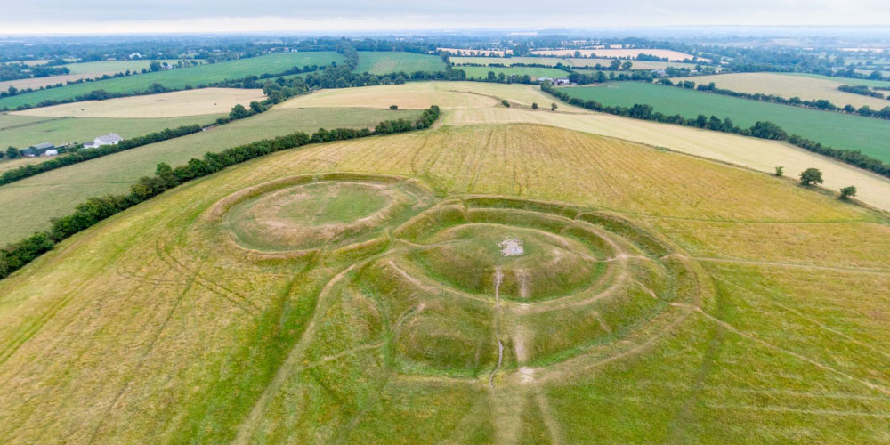
The Hill of Tara is not at all imposing when viewed from the east, the approach of the modern visitor. But its western edge is steeper, and from this mere 155 m (509 ft) height, much of the gently rolling north central plain of Ireland can be seen. The monuments are dispersed for some 2 km (1.2 mi) along this low north-south ridge, located between the Co. Meath towns of Dunshaughlin and Navan.
This viewscape of the site may explain its attraction as a locus for ceremonial practices. These expansive sight lines may also account for one of the explanations of its Irish name, Teamhair, “a height from which there is a fine view.” An alternate etymology suggests the name refers to a liminal zone (transitioning point), or an area cut off for a sacred purpose. This demarcation of zones, the sacred and the profane, is made evident by the ancient ditch cut around the top of the hill, Ráith na Ríg.12
In the Dindshenchas Érenn, the listing of place-name lore dating from around the 11th century, the name Teamhair derives from the burial place of Tea, the daughter of Lugaid, Tara’s first king.13 The name also resonates with the Greek temenos, a sanctuary, and the Latin templum, or temple. The stories of Tara in the Dindshenchas were likely written with the patronage of the Ui Neill kings at Tara, with the intent to promote that house in the competition for primacy among the different regional kings of Ireland.14
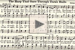
The Harp that Once through Tara’s Halls is sung here by John McCormack.
“The harp that once through Tara’s halls
The soul of music shed,
Now hangs as mute on Tara’s walls
As if that soul were fled.
So sleeps the pride of former days,
So glory’s thrill is o’er,
And hearts, that once beat high for praise,
Now feel that pulse no more.
…”
(Thomas Moore)
The Legends of Tara
“The feis [festival] of Teamur each third year,
To preserve laws and rules,
Was then convened firmly
By the illustrious Kings of Erin.” 15
(Annals of the Four Masters)
The first mention of Tara occurs in a text of 7th-century origin, Baile in Scáil (“The Phantom’s Vision”), in which Lugh, the greatest of the Celtic gods, presents a list of kings who will rule from Tara far into the future.16
In the Lebor Gabála Érenn (Book of Invasions, c. 11th century), when the Son of Mil (the Milesians) sailed to Ireland, they first encountered the supernatural Túatha Dé Danann at Tara. Later, in the battle at nearby Tailtiu (Teltown), the invaders prevailed, forcing the Túatha Dé Danann into exile underground, where they exist as today’s fairy folk.17
Lugaid Lámdearg was said in the chronicles to be the first king of Tara, and what followed was reputedly an unbroken succession of kingship generations, down to Niall of the Nine Hostages, fourteen generations later.18 The Bardic history recounts a total of 142 kings who ruled from Tara Hill, spanning some 1,855 years. Of these kings, 136 were said to be pagan and six of them Christian.19 Lugaid and his successors symbolically confirmed their kingship by a ritual mating with Medb, who represents flaith Érenn (“sovereignty of Ireland”) as well as “intoxication.” She “…would not allow a king in Tara without his having herself to wife; and by her was built the royal rath on the side of Tara…”20
Thus, the Feast of Tara (Feis Temro) was said to have begun as a fertility rite, which culminated in the anointment of a sacred king. According to legend, it was last held by Diarmait mac Cerbaill in 560 and then discarded by the Christian rulers as a relic of paganism.
Centuries later, the motif of the Tara kingship was embraced by the early-medieval writers composing the “synthetic history” of Ireland. They formulated stories, repeated to this day, that presented a “high-kingship” that is at odds with the reality of a more regional and tribal royalty distribution, which, while centered for many generations on one or the other of the branches of the Uí Néill, never really featured a dominance over all of Ireland until the campaigns of Brian Boru around the start of the 11th century.21 In the traditional literature, from the 14th to the 19th centuries, Tara is mentioned as one of the four major royal sites in Ireland, alongside Rathcroghan (Co. Roscommon), Navan Fort (Co. Armagh), and Knockaulin (Co. Kildare).
According to a legend in the Book of Leinster, when the great hero of the Ulster Cycle, Cúchulainn, was slain in battle, his severed head and his right hand were buried at Tara, with his shield used to scoop up enough earth to cover the remains.22
At the dawn of the Christian era in Ireland, Tara had a central role in the symbolic collapse of the old Druidic order. St. Patrick, it is told, grew frustrated with his inability to convert King Lóegaire, then the king at Tara. Despite being warned against it, Patrick traveled ten miles across the valley to the Hill of Slane. There he lit Ireland’s first Paschal Fire on Holy Saturday of the year 433. A Druid told the king, “unless that fire be extinguished to-night it shall never be extinguished in this land.”
“Lóegaire and his court had immediately set out for Slane, wheeling their horses and chariots left-hand-wise against the sun’s course in order to bring misfortune upon the foreign priest. But no one extinguished Patrick’s fire that night.” 23 (Alice Curtayne)
In our initial VR view of the Banquet Hall there is a link to the Hill of Slane at the horizon. A modern experiment to recreate St. Patrick’s audacious Paschal Fire may be viewed here. The challenge St. Patrick posed to the elites at Tara in the 5th century had a reprise of sorts in the 20th century, as you will see below in the discussion of the Lia Fáil. Observing that Patrick’s visit to King Lóegaire at Tara “occurred three thousand years after some important prehistoric person had been buried in [the Mound of the Hostages],” Glyn Daniel noted, “Here there must be some continuity with the elder faiths.”24
The final break, according to legend, was the “Curse of Tara” which led to the abandonment of the site after 565. This occurred when King Diarmait mac Cerbaill defiled the sanctity of a church by forcibly removing a hostage who had sought protection there. In response, St. Ruadán prophesied that the king would be killed by the roof-beam of his hall at Tara. In an attempt to forestall his demise, Diarmait ordered the beam to be thrown down and cast into the ocean. But the beam was salvaged, and installed in another castle, where it eventually fell upon the visiting king.25
The Monuments
“…5,000 years or more ago, someone chose that hilltop as a focus for activity, and each intervention subsequently created a remembrance, and each remembrance encouraged new intervention. And so began the process of accretion, creating this crust of history and myth.” 26 (Barry Cunliffe)
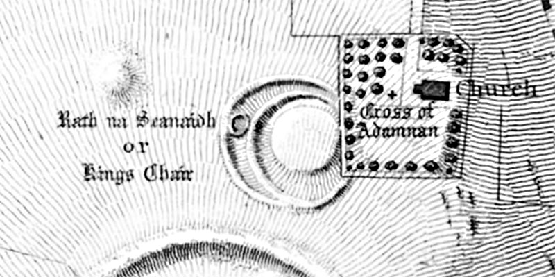
The first serious investigation of the monuments at Tara were the efforts by Thomas Larcom, John O’Donovan, and George Petrie to correlate the descriptions of the site in the Dinnshenchas Érenn (Place Name Stories, c. 12th century) with what they observed on the ground in 1836, some eight centuries later. This excerpt from Petrie’s account (right) explains their methodology.27
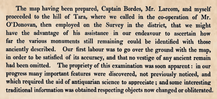
The map resulting from their efforts may be seen in detail by clicking on the thumbnail, below right. For more than a century afterwards this antiquarian fieldwork, with its agenda based upon medieval tradition, stood as the foundation for both the scholar’s and the layperson’s understandings of the monuments on the Hill of Tara.
“…the Tara of myth and history is essentially a product of the medieval literary imagination, a legacy of the post-AD 500 historical era, whereas the archaeology of Tara is almost entirely a product of the prehistoric era.” 28 (Muiris O’Sullivan)
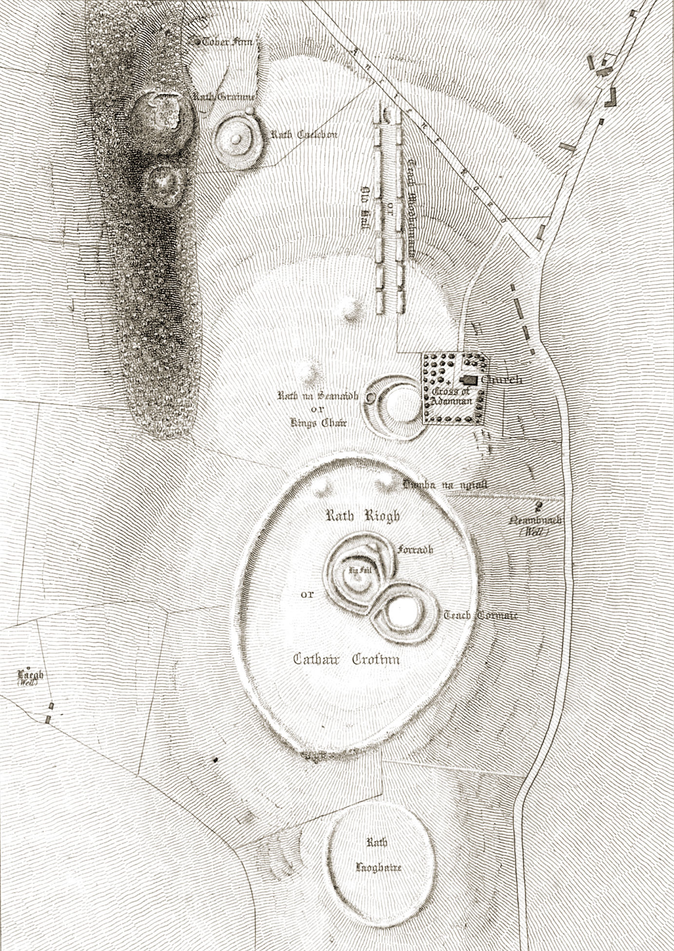
Ordnance Survey Plan, 1837
In the modern era, Seán P. Ó Riordain conducted excavations at the Rath of the Synods in 1953 and 1954, and at the Mound of the Hostages in 1955 and 1956, later completed in 1959 by Ruaidhrí de Valera.29 Their fieldwork was carefully considered when Duma Na NGiall: the Mound of the Hostages, Tara was published a half century later by Professor Muiris O’Sullivan.
Under the leadership of Conor Newman, the Discovery Programme undertook a multidisciplinary survey of the prehistoric monuments on the Hill of Tara in 1992, with publication of the results in 1997’s Tara: An Archaeological Survey. The survey was the first to make use of the newly available Geographical Information System (GIS) measurement technologies, including LIDAR (Light Detection and Ranging) surveys, which can take thousands of radar measurements during a single helicopter flight, revealing data that would have necessitated years of work on the ground. That same year Helen Roche began her excavations of a small part of Raith na Rig. In late 1998 the Discovery Programme engaged Joe Fenwick and Conor Newman and the Centre for Archaeological Survey (NUI Galway) to conduct additional geophysical surveys at Tara, one of which revealed the extraordinary and previously unknown ceremonial enclosure: the Ditched Pit Circle.
In the paragraphs below, we describe each of the key monuments on the Hill of Tara. We will begin with those on the northern part of the Hill of Tara, and then work our way down to those at the southern part of the Hill. Other features are mentioned in the concluding paragraphs of this section. Each of the thumbnail images at the right, when clicked, will load that monument’s virtual-reality (VR) aerial view in a floating window.
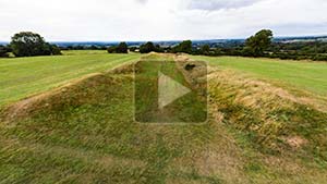
Ráth Gráinne (Gráinne’s Fort)
The second largest barrow (burial mound) on the Hill of Tara, Ráth Gráinne has a diameter of 70 m (231 ft), smaller only than the Northern Clóenfherta. Its size may suggest that it was once the resting place of a person–or persons–of high status. Unlike the disfigured Sloping Trenches, Ráth Gráinne is extremely well preserved, even retaining evidence of two earlier barrows that were incorporated within its banks. These features, not easily noted in the aerial panorama, can be distinguished in the LIDAR scan.30 In addition, there is evidence of other barrows in the field to the north, as may be noted in this 1978 aerial photograph.31
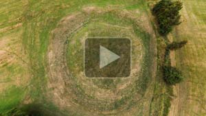
Aerial VR View of Ráth Gráinne.
The traditional literature gave this particular barrow (as identified by George Petrie and John O’Donovan) its name from the mythical Gráinne, the princess daughter of the legendary High King at Tara, Cormac mac Airt. She was betrothed to the leader of the Fianna, Fionn mac Cumhaill. But Gráinne instead fled from this arranged marriage with her lover Diarmuid ua Duibhne, one of Fionn‘s warriors. She may have had little choice, as Diarmuid was supernaturally irresistible to women due to the ‘love spot” on his forehead.32 Of course, there are many versions, and threads, to this story; one of these is considered in our page on the Rostellan Dolmen.
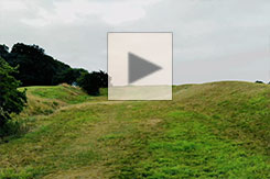
The Sloping Trenches (Clóenfherta)
The Sloping Trenches (Clóenfherta) are a complex of barrows (burial mounds), divided into the Northern Clóenfherta and the Southern Clóenfherta, with three much smaller mounds in between them. Due to their great size—the larger (northern) barrow is 80m in diameter—the Clóenfherta are thought to have been interment sites of high status. Unique among the monuments on the Hill of Tara, the Sloping Trenches are located directly on the steep western edge of the hill, with parts of
Aerial VR View of the Sloping Trenches.
the barrows actually extending down the hillside. Explanations for how the Clóenfherta came to be located on this precipice are laid out in the Dindshenchas (Place Name Stories, c. 12th century). These stories may describe a geographic failure occasioned by a failure in the proper order of things.
It was written that the Northern Clóenfherta collapsed over the hill in response to a false judgment by the King of Tara, Lughaidh Mac Con. This event was said to signal that young Cormac mac Airt would be realized as the rightful claimant to the kingship.
In another story, the Southern Clóenfherta took its shape after thirty Leinster virgin princesses and their retinue were slain there by Dunlaig, king of the Laigin, on the feast of Samhain (November 1).33
The topography of the Sloping Trenches is difficult to discern on the ground due to the vegetation, their location on the side of a hill, the footpaths bisecting them, and the large hole dug into the Northern Clóenfherta, possibly by treasure hunters. Even from the aerial perspective (above, right) the shapes are confusing. However, using LIDAR scans of the site undertaken by the Discovery Programme, a better visual representation is available. Click on the image (left) to explore the Clóenfherta as a 3D object.34
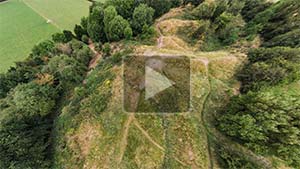
The Banquet Hall (Tech Midchúarta)
“Teach Midhchuartia in the time of Cormac O’Cuin: three hundred feet was the measurement of that house, and seven cubits the length of the fire-place, and seven chandeliers in that palace. Twice seven doors in that royal house. Three times fifty heroes in each imdha [compartment]. Cormac had fifty lawgivers. Fifty heroes stood up in the presence of the king while he was eating. Three times fifty cup-bearers in that dun [fort]. Three times fifty goblets of carbuncle [red garnet], of silver, and of gold. Fifty above a thousand to be enumerated the household of that king.” 35 (Dindshenchas Érenn)
Aerial VR Views of the Banquet Hall.
Although identified with King Cormac’s Banquet Hall since the mid-19th century, this unique feature on the Hill of Tara, with its two 200 m (656 ft) parallel earthen banks flanking its sunken central avenue, is understood today to be a type of “cursus” monument: a grand processional boulevard that may have focused the gaze of the new king toward the tombs of his revered ancestors as he walked through the cursus to his inauguration ceremony.36
Banquet Hall Procession
As Conor Newman put it, “…this one monument harnesses history, mythology and symbolism in the creation of an entrance approach worthy of this most sacred of arenas…”37 How might the king have experienced the sights and sounds as he walked the length of the cursus? Play the video (left) to find out.
“In designing a monument that allowed complete control over what was revealed and what was hidden from sight, the builders of Tech Midchúarta succeeded in creating a space that united into one coherent and integrated composition a host of existing monuments on the Hill of Tara.” 38 (Conor Newman)
The medieval sources provided the name “Tech Midchuarta,” usually translated as “House of Mead Circling,” which is how the name “Banquet Hall” was derived. But some sources call it the “Palace of the Vain Women,” the “Great House of a Thousand Soldiers,” or the “Heroes’ House.”39
With its origin perhaps dating to a ceremonial use in the Neolithic, the cursus likely was repurposed for kingship inauguration rituals continuing into the early historic period. To get a sense of what a king-to-be might have heard, triumphantly walking up this avenue, see the video above. There is a similar cursus monument, the Knockauns, associated with the Tailteann monuments.40
The Banqueting Hall, from a large-format 1979 photograph.
In the popular imagination, however, the twin banks, rising around 2 m (6.5 ft) above the interior, are thought to be the foundations of a fabulous regal banqueting hall, the five or six gaps on each wall perhaps the doors to the hall. Here, every three years, during the late fall festival of Samhain, the Feis Teamhrach was held. At this occasion the formal seating arrangements and the distribution of the portions of meat were dictated by the tribal culture. The images of this “banquet hall” were deeply ingrained in the Irish—and Irish Diaspora—cultural identity. The aforementioned “Harp that Once…” (listen here) is a patriotic paean to a lost grandeur, evoked through this flight of archeological fancy.
Rather than being a “voice from the dawn” of the Iron Age, the depictions of this cursus as a banquet hall reflect the cultural norms of the Christian monks who authored these accounts during the Middle Ages. They may have known where the ritual pagan sites were located, but with no information regarding their original purpose, they “turned them into royal halls filled with warrior aristocrats instead of showing them as the complex ceremonial sites which they were.”41
“According to the Irish concept of kingship, the exercise of royal justice was crucially important to the preservation of the bountiful kingdom. But each member of the tribe also had a prescribed code of action, in which failure to claim a right was as much a threat to societal stability as was failure to meet a responsibility.” 42 (William Sayers)
The medieval descriptions of a Banquet Hall, presumed by 19th-century antiquarians such as John O’Donovan and George Petrie to refer to the cursus on the Hill of Tara, derive from two main sources:: The Book of Leinster and the Yellow Book of Lecan. These texts provide evocative illustrations of social rank and vocation as they list the seating arrangements in the Hall and the portion of meat allotted to each: the poet, the chariot-builders, the musicians, the physicians, the builders, and the others. These divisions reflect the importance of such an ordered universe. Like a pack of feral creatures from the forests, the heavily armed members of the community could only enjoy a repast together if each person respected his place, both in its rewards and its responsibilities.43
In our animated treatment of the 12th-century Book of Leinster’s imaginative and iconic illustration of the Banquet Hall (right), you can click the “play“ button to cycle through three different views of the document. First you will see the original image. The first click on the play button will display George Petrie’s 1839 tracing of the illustration. Another click will show Petrie’s translation into English, with the words he was unable to translate indicated in red. One more click will display our educated-guess translations of these words, assembled from various sources.44
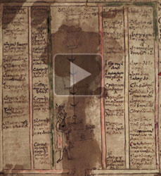
The Banquet Hall as imagined by the 12th-century Book of Leinster. Click the play button to cycle through the four different versions.
In verse and legend, the events within the Banquet Hall went far beyond eating and “mead circling.” If the walls could talk, they would have mentioned the “Tarb feis” (bull feast), which occurred after the death of a king. The soldiers would kill and roast a bull, and then one chosen warrior would continue to eat until he fell into a stupor of sleep. A druid would then make an incantation, and then a vision of the future king would be revealed in the warrior’s dream.45
Some of the furnishings of the Hall itself were said to be magical, such as the supernatural cauldron in which the meat was prepared. The cauldron always seemed to contain just the right quantities of pork and beef, so that when any person put his “fleshfork” (ael) into the pot he would magically spear exactly the correct portion allotted for his station in life.46
For more than 150 years, most visitors to the site, and many of the respected authors of Irish archaeology, accepted without question the myth-inspired identification of the elongated cursus with the descriptions of the great Banquet Hall of King Cormac mac Airt, the most renowned of the fabled High Kings at Tara. There was one significant problem, however. In both of the manuscript illustrations of the Hall (the Book of Leinster and the Yellow Book of Lecan), the plans depict a decidedly rectangular building, not at all representative of the long and narrow cursus found on the Hill of Tara.

Macalister’s Banquet Hall.
Writing in the 1930s, R.A.S. Macalister attempted to “square” the text descriptions of the seating plan with the facts-on-the-ground of the cursus, resulting in his elongated graphical depictions (left) of King Cormac’s hall, far removed from the original illustrations contained in the manuscripts.47
But what if the forced geometry of Macalister was not necessary to validate the existence of a Banquet Hall? According to Dr. Clodagh Downey, there may have indeed been a royal hall on the Hill of Tara similar to that described in the ancient manuscripts. But, she suggests, it may have been sited at locations other than the cursus, because “…the exclusive association of the banqueting hall with the linear monument was a later development.”48
Dr. Downey further argues that the term “tech midchúarta” is not specific to the Hill of Tara but instead may refer to the sites of royal repasts more generically. She cites evidence from her reading of the medieval sources that the Tech Midchúarta at Tara was a temporary structure whose location and dimensions would differ with the needs and dictates of the particular king in power. Thus, she suggests, it may have been that King Cormac’s banqueting hall was located in his ringfort, Tech Cormaic. Similarly, the banqueting hall of King Lóegaire could have been situated in his own fort, Ráith Lóegaire.49
“In contrast to the considerable effort that has been expended in trying to account for the remains of the Tech Midchuarta in terms of written accounts of a regal banquet hall, very little topographical or archaeological analysis has been undertaken and thus it remains one of the most celebrated enigmas of Irish prehistory.” 50 (Conor Newman)
One recently discovered feature of the site has only added to the enigma. When the cursus area was investigated using new digital imaging techniques in 1999, archaeologists found evidence that when the site was in use the southern end terminated at the fosse (trench) of an enormous oval open-air enclosure. Known as the Ditched Pit Circle, or Woodhenge, this double-palisaded monument extended southward to encompass the Mound of the Hostages (see below). It may be possible that the Cursus (Banquet Hall) was part of a “theatre upon which were enacted various rituals of early Irish kingship.”51
The Ditched Pit Circle
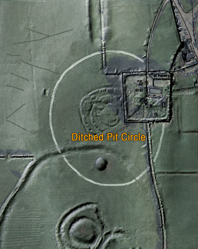
The Ditched Pit Circle
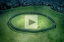
Commonly referred to as “Woodhenge,” this monument presents no evidence of its existence to someone walking on top of it. But it is one of the largest and perhaps most significant features on the Hill of Tara. Called by some “Ireland’s Stonehenge,” the 170 m (560 ft) diameter oval monument is known primarily from the data derived from geophysical survey instruments, probing beneath the soil. “Woodhenge” begins south of the Banquet Hall (the Cursus), encompasses the Rath of the Synods, and extends south beyond the Mound of the Hostages. The feature was first identified in 1998-9 by Joe Fenwick and Conor Newman (NUI Galway and the Discovery Programme).52
The enclosure, dating from c. 2500 BCE,53 is defined by its 6 m- (20 ft-) wide and 3 m- (10 ft-) deep ditch, and features, on either side of the ditch, evidence of some 300 regularly spaced post-holes. The size of the post-holes—2 m (6.5 ft) in width—suggests that the timber uprights were massive, several meters in height.

Joe Fenwick using an electrical resistance meter.
“It fills a very important place in the jigsaw [puzzle] because it allows us to make sense of the distribution of other monuments all around it.”
…
“There can be no doubting, for instance, that Ráith na Senad, dating from the first few centuries AD, was deliberately placed at the centre of it, even though it [Woodhenge] was by then a very ancient enclosure indeed.” 54 (Conor Newman)
Fenwick believes that the upright posts would have formed a palisade with connecting crossbars, similar to the stone uprights with horizontal lintels seen at Stonehenge. He believes it’s possible that that this “Woodhenge” structure could have been elaborately decorated, designed to create a compelling ceremonial space. Today’s visitors to the Hill of Tara, who may have no idea that they’re walking within the sacred arena of Woodhenge, might be astonished to see it depicted in the excerpt from The Secrets of the Stones (2009, RTÉ), to the right.
Excerpt from The Secrets of the Stones: The Ditched Pit Circle.
The discovery of this monument deepens our understanding of the cursus (ceremonial avenue—see the Banquet Hall, above). Since the northern edge of Woodhenge intersects the southern end of the cursus, it may be that the inauguration of a new king required him to walk the length of the cursus, passing by and acknowledging the tombs of his ancestors, prior to his ceremonial investiture in the center of the sacred space defined by the Ditched Pit Circle. However, the archaeologists could find no clear evidence of an entrance to the circle. According to Newman, the entrance may have been somewhere within the unsurveyed area in the adjacent churchyard.55
The monument would likely have retained some above-ground presence into the first few centuries of the Common Era. However, while some other monuments that are no longer upstanding today are nevertheless mentioned in the Dindshenchas (see below), the medieval literature contains no clear references to the Ditched Pit Circle. Is it possible that the once-magnificent “Irish Stonehenge” was entirely dismantled, burned, and back-filled long before the compilation of the Dindshenchas in the 11th century? It may forever remain a mystery whether some cosmic event or a dramatic change in religious practices caused the removal of this grand and imposing feature on the landscape of Tara.56
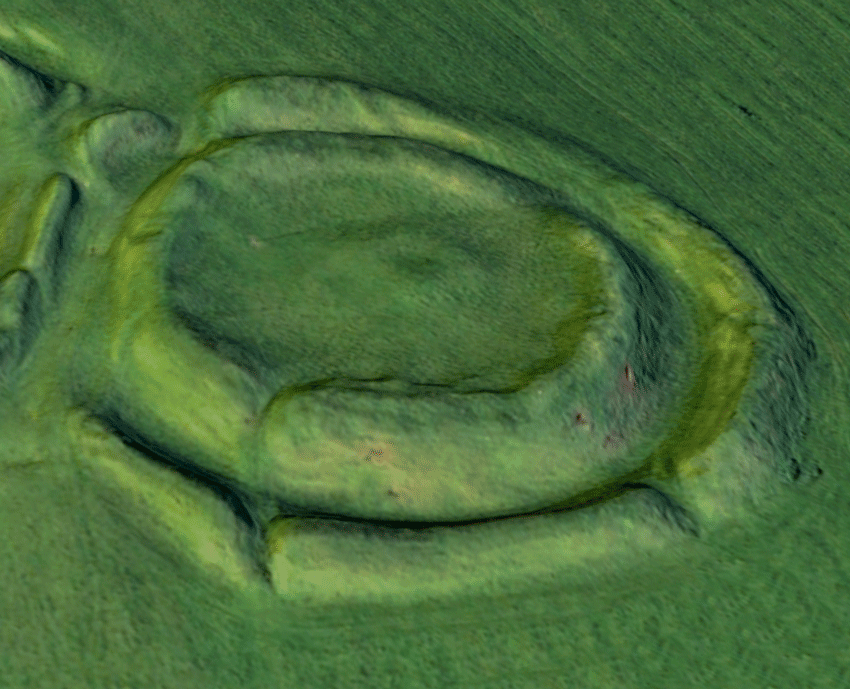
Ráith na Senad (Rath of the Synods)
“The explorations at Tara by the British-Israelites, and the media campaign engineered by Irish cultural nationalists in response, were a watershed in Irish archaeology. It was the first time that the Irish media had been involved in a campaign to protect a national monument.” 57 (Mairéad Carew)
As Petrie described it, the monument was the “site of Pupall Adamnain” (pavilion of Adamnán).58 St. Adamnán (c. 624–704) was the last of the four saints said to have held synods (councils) on the site, preceded by St. Ruadhan, St Brendan, and St. Patrick. Notably, Adamnan established in 697 the law guaranteeing the safety of women and children during warfare.59
Aerial VR View of the Rath of the Synods.
In the detail (below, left) from Petrie’s 1837 map, the shape of the rath (fort) as he found it may be clearly noted. But due to the archaeological carnage caused to the monument by a motley crew of fanatical vandals at the end of the 19th century, the earthworks today look very different. Consequently, what may be termed the “modern folklore” of the Rath of the Synods, with its nod to the 1981 film Raiders of the Lost Ark, is better known than the traditional tales from the Dinnshenchas.
Petrie’s 1837 sketch of the Rath of the Synods.
From the excavations in 1952-3 by Seán Ó Ríordáin, we know that the monument had three distinct phases of construction. The first, around 200 BCE, was an oval ring-ditch enclosure with a barrow. This was followed by a complex of trenches, which once featured large circular enclosures made of wood. Numerous post-holes for this Iron Age site suggest a double timber circle, which may have had ritual significance. Following this period, the site was used as a burial ground for perhaps the first two centuries CE.60
The final phase of construction at the site was a ringfort (CE 200-300) with four banks and ditches. This site likely had domestic structures within it, surrounded by palisades. The discovery of Roman artifacts from this occupation suggests the elites in residence were in contact with Roman civilization.61 Two golden torcs found nearby may be seen in the image, below left. Perhaps these treasures, considered the “finest objects of the period,”62 may have been buried by a besieged occupant of the ringfort in a moment of desperation.
It is difficult today to identify the shape of the Rath of the Synods due to the construction of the churchyard walls to the east and the townland boundary to the south, both clearly illustrated in the satellite view. But, most significant is the devastation caused to the monument by “excavations” conducted by the British Israelites between 1899 and 1902.
“A.E.I.O.U.Y.
Angliae Est Imperare Orbi Universo Yisraelan.
It for the Anglo-Israelites to dominate the Universe!” 63

The doctrine of the British Israelites was described by R.A.S. Macalister as “an abortion begotten of unscholarly ignorance of the nature of the Biblical historical record, upon unbridled national bumptiousness.”64
If you identified as a British Israelite near the end of the 19th century, you fervently believed that the Jews of your era were not the legitimate descendants of the twelve tribes of Israel. Rather, through a path of tortuous logic you would believe that the Jews were only a minor percentage of the “chosen race,” perhaps two tribes out of twelve; the other ten were YOUR people, the Anglo-Saxons.65 It’s best not to spend too much time working out the logic here, but their reasoning was: “Since the ancient Hebrew prophets foretold a wonderful life for the Israelites in the distant future, the fact that we Britons, living in that distant future, are so prosperous, must mean that we are the Israelites.”66
The 1899 “excavations” at the Rath of the Synods.
The first known British-Israelite was Richard Brothers, who began experiencing his visionary millenarian revelations in 1791. He announced that he was “Prince of the Hebrews and Nephew of the Almighty,” and as a descendant of biblical King David, he claimed the British throne.67 He was declared insane and committed to an institution in 1795. But the British Israelites themselves claim their origin from the ideas of a mid-nineteenth century Irish weaver, John Wilson, who postulated that the English language was based upon “pure Hebrew,” and then went on to publish “Our Israelitish Origins” in 1840.68
The stated aim of the British Israelites was to “promulgate the important Truth, that the British Empire (Home and Colonial) and the United States of America, are the two Great Peoples into which it was predicted the House of Joseph, or Israel-not-Judah would be divided in these latter days.”69 At its height, in 1920, the British-Israel-World Federation had 20,000 members. Even the Duke of York, the future King George VI, wrote in 1922: “I am sure the British Israelite business is true. I have read a lot about it lately and everything no matter how large or small points to our being ‘the chosen race.'”70
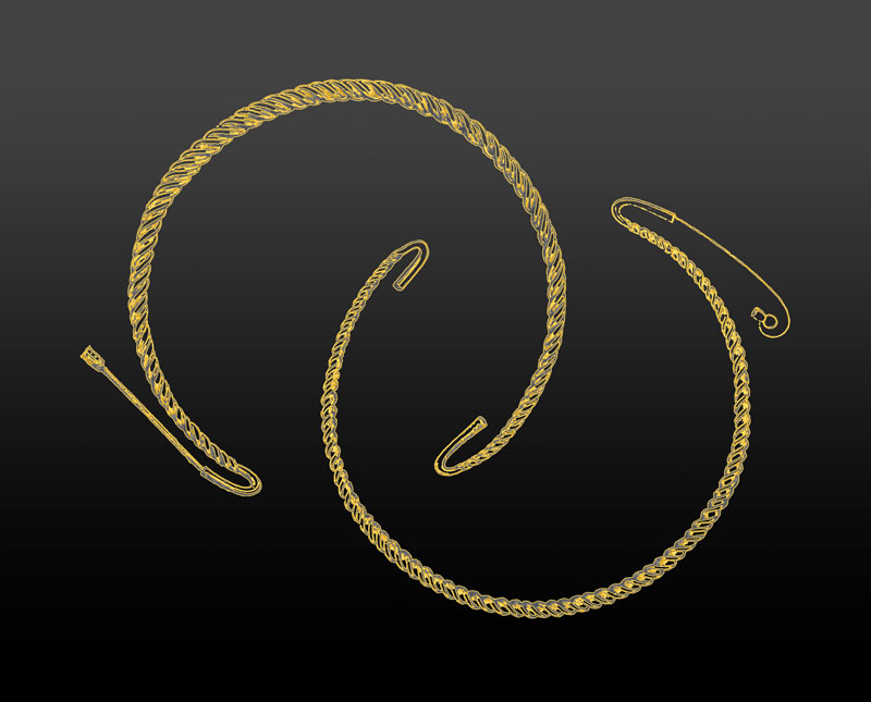
The “Tara Torcs” were found in 1810 near the Rath of the Synods.
The “House of Judah,” as their contemporary Jews were referred to by the British Israelites, were relegated to secondary status in the eyes of God. While some in their circle considered that the Jews, while subordinate to the Ten Tribes (aka the British), were still an important part of the biblical enterprise, it is clear that the British Israelites considered themselves, and not the Jews, entitled to the promised land of Israel. But how did Ireland’s Hill of Tara become the geographic focus of their belief system?
As the 19th century was drawing to a close, an Englishman named Charles Groome used a “bizarre hotchpotch of Egyptian hieroglyphics” (see an example in the gallery below), and indecipherable signs and patterns from prehistoric monuments71 which, combined with his reading between the lines of an 11th-century poem, led him to an inescapable conclusion: Princess Tea Tephi, reputedly the daughter of a Pharaoh who escaped from the Holy Land with the Ark of the Covenant, was buried on the Hill of Tara, along with the Ark.72
Groome obtained permission from the men who owned or leased the site, and with his team of devotees and hired laborers set about digging for the fabled treasure. Within a short time, it was said, two of the three Irishmen who permitted this “excavation” were to suffer untimely deaths.73
The Mounds at Tara
“The Ark of God, adorned with Gold,
Shall yet be found at Tara;
The law on stone which it doth hold
Shall yet be found at Tara;
Engraven there by God’s own hand,
And hid away at His command,
Joy will reign throughout the land
When they are found at Tara.” 74
While the British Israelites at first identified the central mound within the Forrad as their target for the grave of Princess Tea Tephi—and the coveted Ark—they migrated to the Rath of the Synods once they had permission to dig there.75 The diggers (it would be an embellishment to call them “excavators”) were solely focused upon the Ark, and thus cared little about any collateral discoveries, and kept no account of their depredations to the monument. Their diggings material, which they treated as “rubbish,” was not screened or otherwise examined for what it might contain. Fortunately, a nearby landowner, Sir John Dillon, frequently observed their work and kept a record of what he saw.
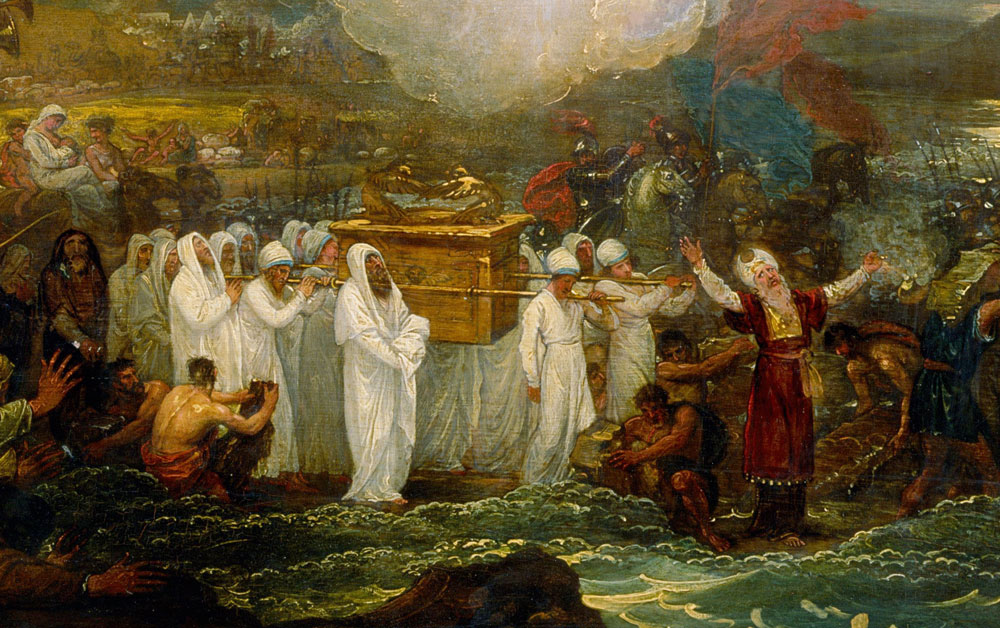
“Joshua passing the River Jordan with the Ark of the Covenant,” by Benjamin West, 1800 (detail).
Dillon described the British Israelites working at the monument as if “to scoop [it] out like a cheese.” The diggers found bones, a golden bracelet, two large stones described as ”altar stones,” as well as Roman coins, as they worked on the inside and then on the rampart of the enclosure.76
They found a deep rock-cut trench (see photograph in gallery, below) which may have indicated an important archeological feature. However, without the excavation notes nothing can be certain of it. But just as the British Israelites were planning to begin digging up the Mound of the Hostages, 30 m (98 ft) away, a coalition of newly-energized cultural nationalists intervened and finally put an end to the destruction. The effort took nearly four years, due to the lack of governmental authority to stop the work when the landowner and his tenants were in favor of permitting it.77
“Tara was regarded by the British-Israelites as a powerfully symbolic site, their ‘resuscitated’ Jerusalem…To the cultural nationalists Tara was the capital of a future independent Ireland, free of the shackles of the British Empire. Both sides drew on interpretations of history and mythology to explain their actions.” 78 (Mairéad Carew)
At the turn of the century the scientific practice of archaeology was supplanting the traditional world of the antiquarian, in which legends and imaginative speculations were considered legitimate paths to an understanding of the country’s ancient monuments.
The Rath of the Synods, from a large-format 1979 photograph.
However, the forces in 1902 that put an end to the British Israelite vandalism were not those of sober scientific enquiry. Rather, there were two alternate mythologies that competed head-to-head. The British Israelites, in addition to their supposed Biblical sources, drew upon the 18th-century antiquarian meditations of authors such as Charles Vallancey and Henry O’Brien.79
But the resurgent Irish nationalists were evoking the vision of a Celtic millennium, where the native culture was an intrinsic part of the yearning for an independent Ireland, free from the confines of a colonial empire. From this perspective, Tara was “the capital of a free and independent Ireland, a mythical place that served as imaginative fodder…” for writers, politicians, and poets.80 Once the crusading politicians and poets took up the cause of protecting the Hill of Tara, the British Israelites were forced to withdraw. Even Maud Gonne, W.B. Yeats’ muse and fellow spiritualist, contributed a visionary experience to the effort.81
When Douglas Hyde, George Moore, and W.B. Yeats wrote a forceful letter to the editor of the London Times in June of 1902 (see in gallery below), they were adding their voices to an ascendant political chorus of nationalism.82 In late July or early August of that year the British Israelite destruction at the Rath of the Synods was finally ended due to “popular indignation and its possible consequences.”83


The racial components of their movement, however, endured. While the British Israelites themselves were not particularly anti-Semitic (considering their era84), the racial notions that they promulgated were easily adapted by those with a more hateful agenda.
At about the same time that the Nazis’ poisonous doctrines were becoming ascendant in Germany, some of the British Israelites’ dogmas were becoming aligned with the Christian Identity movement. This was really not that much of an evolution, as intrinsic to their worldview was the notion, not that uncommon in their day, that the British Empire had been given a mandate by God to rule the world. In fact, “Identitist” was a term already associated with the British Israelites, due to their “identification” of the British Empire with Israel.85
“Tara is a peculiar place. It attracts curious tourists by the busload, modern ‘druids’ and people who like Tolkien a little too obsessively; it attracts the painfully mad and the frighteningly eccentric.”
“They lay claim to Tara… but the reality is that they bear very little in common with the ancient Celts of Ireland, which is a good thing – they don’t head hunt, they don’t practice human sacrifice and they don’t have the same blood lust!” 86 (Excerpt from a blog post by “Adomnán.”)
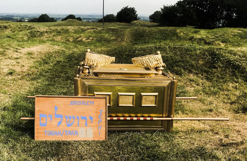
In June of 2018, a new generation of British Israelites brought their Hollywood-inspired ark to the Rath of the Synods.
The Christian Identity offshoot of their doctrine extends the exclusivity of the British Israelites to include all of the “white race.” But in a more sinister turn, it claims that present-day Jews are willful imposters of the descendants of the Israelites, have no souls, and are in fact the children of the devil.87
In the era of the Web, it is unfortunately a simple matter for those with ideas at the farthest margins of public discourse to band with their cohorts and make a noise far out of proportion to their numbers. There are still British Israelites out there, and some of them remain focused upon the Hill of Tara. Just as their millenarian forefathers did at the close of the 19th century, at the end of the 20th a man named John Hill prophesied that it would be found underneath the Mound of the Hostages, and he sought permission to dig for it there.88
In June of 2018 a group of British Israelites enabled their fantasy of a millennial-caliber treasure by carrying their homemade version of the Ark up to the Rath of the Synods (see photo above right). They stood nearby and harangued the crowds of bemused tourists, proclaiming themselves the true inheritors of the sacred ground.
The Churchyard
There is scant evidence of the original 12th-century parish church built on the Hill of Tara, in ruins by the 16th century, with but a meagre remnant of one wall remaining. This may be noted in the background of the black and white photograph (below, left). This church was in ruins by the 16th century.89 The original church was demolished, with some of its 15th-century architectural elements used in the modern Church of Ireland structure, Saint Patrick’s, built in 1822-3.
VR View of the Churchyard.
This is the church seen in the virtual-reality panorama (above, right), whose western wall intruded upon and obliterated the eastern edge of the Rath of the Synods. The church was deconsecrated in 1991 and now functions as the Hill of Tara Visitor’s Center, although religious services are celebrated there yearly on St. Patrick’s Day.

The stones of Blocc and Bluigne.
The taller of the two stones in the panorama may be a remnant of the “Cross of Adamnan,” commemorating the 7th-century saint who was reputed to hold his councils at the adjacent Rath of the Synods. While it is difficult to discern in the VR view, the top of the stone seems to be segmented, perhaps to facilitate the attachment of the arm of a cross. This may be noted in the T.J. Westropp sketch from 1894, provided as a pop-out image in the VR.90
This stone, when paired with the smaller pillar to its east, may be those identified from the traditional literature as Blocc and Bluigne, named after two druids. With their implied male and female associations, the smaller (.75 m or 2.5 ft), and likely more ancient of the two, is the male (Blocc), while the larger (1.88 m or 6 ft) squared pillar (Bluigne) is the female. These magical “druidical stones”91 were central to the Tara kingship inauguration ritual. As Christine Zucchelli envisioned it:
“Wearing a cloak that would only fit a true king, Conaire had to drive a chariot drawn by horses that only a worthy applicant to kingship could control. Arriving at Tara, he had to pass the final ordeals. There were two flagstones at Tara, called Blocc and Bluigne, which stood so close together that one’s hand could only pass sideways between them. When they accepted a man, they would open before him until his chariot went through.” 92
Perhaps the most astonishing thing about the Cross of Adamnan (Bluigne) is the primitive, yet very suggestive, 46 cm (18 in) carving of a Sheela-na-Gig on the lower third of the stone: a worn and now barely noticeable image of a squatting woman, knees held apart, exposing her genitals. The figure was much more distinct in earlier photographs. The fact that such carvings are usually found incorporated on the walls of churches, and not on free-standing stones, gives some credence to the theory that this pillar was once an architectural element of an earlier church at the site.
Some of the folklore regarding Sheela-na-Gigs identifies them with a pagan fertility cult; this example in particular has been invoked in such arguments, perhaps because some observers have noted “antlers,” or some other type of ceremonial headgear on the figure. It was said that women seeking to become pregnant would rub the ancient carving for good fortune.93 Yet most historians now date these figures to the medieval era, with their purpose and meaning open to speculation. An additional discussion of Sheela-na-Gigs may be found in our page about the Ballyvourney Monastic Site.
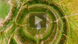
Ráith na Ríg (Fort of the Kings)
By far the largest feature on the Hill of Tara, the Iron Age “Fort of the Kings” is an oval-shaped enclosure a full kilometer (.62 mi) in circumference, encompassing within important monuments from much earlier cultures. Now consisting of an earthen bank outside a ditch, there is evidence that it once featured a “stout wooden palisade”94 along its inside edge, forming a stockade protecting the enclosure. Due to its assimilation of the sanctity of the earlier funerary monuments, it likely had a significant ceremonial purpose.
Aerial VR View of Ráith na Ríg.
While there is no way to know the nature of such ceremonies, human burials and a profusion of horse and dog bones found within the ditch suggest a ritual function. The fact that a small workshop for forging items of irons, bronze, and even glass was found buried beneath the bank of the monument, predating it by a generation or more, may suggest the magical abilities ascribed to skilled craft persons in the Iron Age.95
Archaeologists have found no evidence of what might have been the original entrance to the enclosure, but excavations and geophysical data have suggested three possible locations for entrances constructed at a later date.96
Taking its name from medieval tradition in the Dinnshenchas, Ráith na Ríg was the location of the “three wonders of Tara”: the Forrad, Tech Cormaic, and Mur Tea. The first two of these are discussed below. The third was Múr Tea, the Mound (or Wall) of Princess Tea Tephi, the Egyptian wife of Érimón, one of the legendary kings of Tara. While Tea Tephi may have given her name to Tara, her reputed burial site has not been definitively located. Princess Tea Tephi figures prominently in the British Israelite dogma regarding the location of the Ark of the Covenant (see Rath of the Synods, above).97 Ráith na Ríg also encompasses Duma na nGiall, the Mound of the Hostages (see below). Aerial surveys and geophysical data indicate that there may have been at least six other monuments, now imperceptible on the surface, located within the extensive 8.4 hectares (20.7 acres) rath. These are briefly discussed below.98
According to Gerard Dowling, Ráith na Ríg may be best understood as a liminal (transitional) space that served to demarcate its ritual-use interior from the surrounding secular environment. This may explain why the remains of people and animals, as well as artifacts, were for many generations deposited within its ditch.
“If the ditch was thus endowed, however, then it also represented a place from which potentially devastating forces could emanate. Ritual offerings and the accompanying ceremonies may have been enacted to placate the supernatural and paranormal, and to prevent the corruption of the sacred space itself.” 99
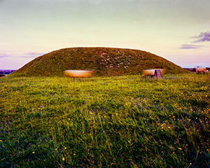
Duma na nGiall (The Mound of the Hostages)
Thousands of years before the Fort of the Kings was built around it, someone was entombed on the site that would become the Mound of the Hostages, the oldest visible monument on the Hill of Tara. This person—perhaps a young Bronze Age prince—has become known to archaeologists as “Tara Boy.” He was buried wearing a necklace (below) of jet (lignite), amber, bronze and faience (tin-glazed pottery). The rarity of these types of beads in comparable Irish burials points to Tara Boy’s elevated status in his community. The amber beads in particular “appear to be without parallel in Early Bronze Age Ireland…”100
VR Views of the Mound of the Hostages.
During the next 1,500 years the mound and its associated burial pits were to be the final resting place for more than 300 men, women, and children.
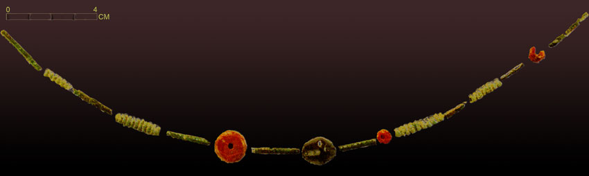
The “Tara Boy” Necklace.
Over the centuries it eventually became so crowded inside its 3 m (10 ft) passageway that later burials were scattered around its clay mantle. Some of the charred remains were placed underneath inverted funerary urns (Carrowkeel Ware). One of these, with its accompanying smaller “food bowls,” may be seen in the photo, below, right. Muiris O’Sullivan suggests that there might have been a coded ritual meaning to the placement of some of these artifacts, such as the presence of a miniature vessel linked with the remains of a child in the burial cist.101

Encrusted Urn and Food Vessels.
While it dates from the Neolithic, the site gained its common name from the stories in the 11th-century Dindshenchas in which Tara’s legendary King Cormac took hostages from the ruling households of the different provinces to ensure his primacy. Such “hostages” of the time were in fact more like foster children, reared in the home of the king to create bonds of fealty with their parents.102
Before its excavation (1955-6 and 1959), there was no indication that the relatively low mound with the flat top would hold any such extraordinary secrets, as it was notable only for its prominent location at a point where the surrounding Ráith na Ríg seems to bend outward to encompass it.103 Therefore, it is important to note that when Petrie and his compatriots were mapping the Hill of Tara and using the medieval texts as their guide, they had no idea that the Mound of the Hostages was actually a Neolithic passage tomb.
The earliest construction on the site of the Mound of the Hostages, and the earliest identifiable monument on the Hill of Tara, is what was a likely a pre-cairn enclosure, featuring evidence of individual fires and spreads of charcoal, dating from c. 3500 BCE. The construction of the 3 m- (10 ft-) high burial mound above, with its 4 m- (13 ft-) long passage, probably occurred during the second half of the fourth millennium BCE. This happened after the initial enclosure had fallen into ruin.104
“The ancient rituals give us an uneasy glimpse of the prehistoric subconscious. We may wonder, for example, why so many unburnt human skulls lay buried together in the cremated bone in the middle part of the tomb, with no corresponding torsos or limbs. Without allowing our imaginations to lead us to dark places, we might ask why infant long-bones, always unburnt long-bones, turned up occasionally but consistently amongst the cremated adult bone. This suggests that human bone deposition at Tara may not simply have been a final service to an individual, a formal leave-taking in the manner of today, but rather an element of ceremonies focused on the place itself.” 105 (Muiris O’Sullivan)
The Mound of the Hostages, from a large-format 1979 photograph.
The enduring ritual importance of the site is perhaps its most notable feature: while the tomb itself and the pre-cairn cists built against its walls contained the remains of several hundred persons from the late Stone Age, a second period of intense burial activity occurred in the early Bronze Age, both inside and outside the mound. Additional Iron Age and post-medieval features around the mound contribute evidence of its enduring significance. However, after the intense use of the tomb during the Bronze Age, its role seemed to shift from being the center of Tara’s “ritual activity to one of acting as the pivot around which the surrounding ritual landscape emerged.”106
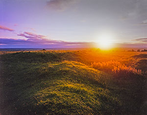
The passage and chamber are divided by sill-stones into three compartments. There is megalithic rock art on one of the upright stones, visible in the virtual-reality environment. The light of the rising sun shines into this east-facing passage twice each year, on the mornings around Samhain (November 1) and Imbolc (February 1).107


An Forrad (The Inauguration Mound)
The Dindshenchas Érenn gave this site (as identified by Petrie et al.) its name. Forad in Old Irish means a “mound” or “earthen platform,” to be used by spectators or as an observation post. The word was not used to describe a site intended for royal inauguration.108 Yet the Forrad has come to be popularly understood as the “royal seat,” or the “inauguration mound.”
Aerial VR View of The Forad.
Archaeologists explain that the nature of this complex monument, encompassing numerous late prehistoric funerary sites, may have imbued it with sufficient sanctity for later generations that it may well have played an important role in Tara’s kingship inauguration ceremonies.109
With a maximum diameter of 89 m (285 ft), the Forrad consists of a central raised mound surrounded by a fosse (ditch) and then two concentric banks, with a fosse between them. The innermost bank shows an outward bulge at three points. It is likely that these protrusions are evidence of earlier burial mounds that were incorporated into the later monument, but in a fashion that was intended, as Conor Newman put it, to “…preserve some of their architectural integrity and proclaim their existence.”110
Newman further suggests that the central mound, positioned on the crest of the Hill of Tara, may actually pre-date the other elements of the Forrad and provide “the focus around which the barrows were arranged, satellite-style.” Atop this mound stands the stone identified as the Lia Fáil, discussed below. Also, it was here, on the top of the Hill of Tara, that the Liberator, Daniel O’Connell, spoke to his “Monster Meeting” of August 15, 1843 to support the repeal of the Union with England (see the engraving near the top of this page).
“…with crowding feet a quarter of a million of people wore the hill-side bare. Here, at the summit, Daniel O’Connell stood, and eager faces turned to him; brave hearts beat high, brave words sounded out. The old Hill felt again the thrill and pulse of life and hope. Again, after long centuries, it echoed to the voice of a true, though an uncrowned Ardrigh.” 111 (Helen Grierson)
One of the smaller mounds incorporated into the inner bank of the Forrad, a small round-topped mound to the south-east, may well be the location of Múr Tea, the legendary burial spot of the mythical queen.112 Múr Tea and the other earlier mounds incorporated in the Forrad are difficult to discern in our virtual-reality view, but they are more easily distinguished in the 3D LIDAR scan.
Lia Fáil (The Stone of Destiny)
Consisting of a coarse white granite, the Lia Fáil was likely quarried and laboriously brought to Tara from at least 80 km (50 mi) away.113 In legend, however, it was brought to Ireland by the Tuatha de Danaan, or perhaps the Milesians.114 Its suggestive phallus shape is probably intentional, as the 1.6 m- (5 ft 3 in-) tall stone appears to have been sculpted to achieve that effect. In fact, as late as the middle of the 19th century the stone inspired the popular name of the Mound of the Hostages: “Bod Fhearghais,” or the Penis of Fergus. The Lia Fail is 190 cm (75 in) in girth.115
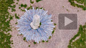
VR Views of The Lia Fáil.
The daguerreotype was still more than a decade in the future when the Lia Fáil was reputedly moved in 1824 to the Forrad from its original location by the Mound of the Hostages. Therefore, there are no photographs of it there. Nor are there any contemporaneous drawings of this ”inauguration stone” depicting it anywhere other than the Forrad, where it was relocated to mark the mass grave of some 400 fallen United Irishmen from 1798’s Battle of Tara Hill.
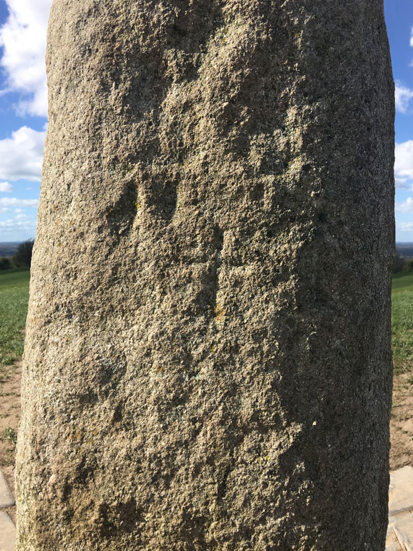
Engraved cross on the Lia Fáil.
It is likely that the cross etched into the stone dates from this move. Now surrounded by a brickwork plaza which highlights the stone’s stature, when we first photographed the Lia Fáil in 1980 it was not nearly as grandly situated.
Although there is some evidence to the contrary,116 Conor Newman points to the 12th-century description of the Lia Fáil as “the pillar-stone of the hostages” as corroboration of the accounts of its original location atop or beside the Mound of the Hostages.117 With this traditional account guiding him, George Petrie mapped the Lia Fáil in that location in 1839.
In its mythology the stone has a symbolic meaning extending much farther back into the history of the struggles for power in Ireland. It is the origin, according to Geoffrey Keating, of one of the poetical names of Ireland: Inisfail (Island of the Stone of Destiny). But, most significantly, the Lia Fáil had a literal “voice” in the selection of the man who would be king.118 In one telling, from “”Conn of the Hundred Battles,” the king-making voice of the stone more resembled a shriek:
“…Conn happened to tread on a stone, and immediately the stone shrieked under his feet so as to be heard all over Tara, and throughout all Bregia or East Meath. Conn then asked his Druids why the stone had shrieked and what its name was, and what it said. The Druids took fifty-three days to consider, and returned the following answer: —
‘Fal is the name of the stone; it came from Inis Fal, or the Island of Fal. It has shrieked under your royal feet, and the number of the shrieks, which the stone has given forth, is the number of the Kings that will succeed you.’” 119
According to some authors, the special audio effects of the kingship ceremony were created by an accomplice hidden in the Mound of the Hostages (the original location of the Lia Fáil) who produced the voice of the stone with an ancient instrument known as a “Bull-roarer.” This lath of wood attached to a string, when whirled around, would produce a haunting and unearthly sound. In our close-up VR view of the stone, you may hear this mesmerizing king-making voice.120

Pamphlet “El-Beth-El, The Stone of History.”
The fame of the Lia Fáil is not without controversy, some of it linked to the miasma of eccentric doctrines which resulted in the damage to the Rath of the Synods (above). The British Israelites maintained (and some still insist) that the actual Lia Fáil is the biblical vision-stone known as Jacob’s Pillow: “[The stone] which the Jews regarded for six hundred years with veneration, as Jacob’s Pillow…being lost in the destruction of their sanctuary, B.C. 588, has appeared in Ireland as the precious Lia Phail, brought thither by Hebrew men in a ship of Dan, cir. 584.”121
Further confusing the history of the stone is the 14th-century account of how the true Lia Fáil was shipped off to Scotland c. 500 CE to secure the sovereignty of the Irish transplanted there. In this version of the stone’s history, all the monarchs of Scotland were crowned upon the Lia Fáil, which became known as the Stone of Scone. Then, in 1296, Edward I of England claimed it as a trophy and installed it beneath a wooden chair, which would come to serve as the coronation throne in Westminster Abbey. This piece of Ireland, if this unlikely mineral lineage can be believed, sat there until the British decided in 1996 to return the stone to Scotland, where it remains on exhibition at Edinburgh Castle.122
Whatever its pedigree, it is abundantly clear that the symbolic power of the Lia Fáil remains capable of provoking passionate intensity. For example, St. Patrick’s and the Church’s victory at Tara with the first Paschal fire may have seemed secure when a statue of the saint was installed next to the Lia Fáil around 1895. The statue was positioned just a bit higher than the ancient phallic stone, where it appeared to mediate between the Lia Fáil and the adjacent monument to the fallen United Irishmen. But when the badly deteriorated saint’s statue was removed for repair in 1992 it was irreparably damaged in the process.

Click to view a composite of all three statues of St. Patrick on (and off) the Hill of Tara.
The winning entry of a 1997 competition to select a replacement sculpture was submitted by Annette Hennessy, whose design was inspired by her imagining how a young Patrick might have appeared during the Celtic pagan-druidic culture of his era. But this failed to find favor in the local community, as they saw the revered saint depicted as “a bald man in a mini-skirt.” The ensuing impassioned debate ended in 2000 with the installation of a more traditional statue of the saint, but one exiled from the Forrad down to the flanks of Tara below. See the composite, above left, of all three St. Patricks.123
In June of 2012 someone struck the Lia Fáil, perhaps using a hammer, causing damage in 11 areas. No fragments were recovered, which may indicate that the miscreant made off with them, perhaps intending to hold their own kingship ritual. Two years later a vandal poured green and red paint on the stone, covering about half its surface. As Terry O’Hagan noted afterward:
“One doesn’t have to look very hard for symbolism and modern-day metaphor in the wanton disregard of a monument intimately associated with early medieval myths & legends surrounding the creation and maintenance of proto-national identity & sovereignty.” 124
Another act of vandalism occurred in 2023.
Tech Cormaic (King Cormac’s House)
In the Dindshenchas, this early-medieval ringfort was the palace of the heroic king of Tara, Cormac mac Airt. Connecting to the Forrad like a modern domestic addition, Tech Cormaic has a meter-high earthen bank with a diameter of 79 m (259 ft). It also features an outer fosse (ditch) and external bank, possibly indicating a residence of some stature, the home of someone very important.
Aerial VR View of Tech Cormaic.
Furthermore, as this is the only residential structure within the Ráith na Ríg (Fort of the Kings), its position there may have been a political statement intended to invoke the symbolic power of the far more ancient burials at the Hill of Tara. More easily recognized in the LIDAR scan (animated screenshot, below left), the fort’s interior shows the faint outline of what may have been a rectangular structure. Could this have been the residence of a king?125
Known from medieval legends as the “noblest and most bountiful of all princes,”126 Cormac mac Airt occupies an uncertain position in history. While he may have had an authentic existence, his reign of 40 years is mentioned variously as happening as early as the 2nd century CE and as late as the 4th. Stories of his early life abound, including his being raised by wolves inside a cavern at the Caves of Kesh. You may enter one of these caves in virtual reality here, and learn more about this legend and the Caves of Kesh, here.
LIDAR view of Tech Cormaic.
“’O grandson of Conn, Cormac,’ said Carpre,
‘What is best for a king?’ ‘Not hard to tell,’ said Cormac. ‘Best for him:Firmness without anger,
Patience without strife,
Affability without haughtiness,
Taking care of ancient lore,
Giving truth for truth,
Hostages in fetters,
Hosting with reason,
Truth without addition,
Mercifulness with consolidation of law,
Peace to tribes…'” 127
(The instructions of King Cormac Mac Airt)
According to the legends, Cormac assumed the kingship of Tara at the age of 30 when the usurper monarch Mac Con walked away from the regal role after Cormac thoroughly embarrassed him by pronouncing a far superior judgment of law.128 Later, Cormac assumed the title of High King when he defeated Fergus Dubdétach at the Battle of Crinna. At the height of his authority, King Cormac is credited with codifying the laws of Ireland into a system that remained in force until the Norman invasion, and even then, continued to be observed for centuries later outside the English Pale. The king is also credited with building the first water mill in Ireland, using the stream which flows from the nearby Well of Nemnach (see below).
The fact that his daughter Gráinne was betrothed to the aging Fionn Mac Cumhail has made Cormac a constant presence in the immensely popular Fenian Cycle of heroic warrior folklore. Since it was considered taboo for a disfigured king to rule at Tara, Cormac passed his throne to his son Cairbre in 254 CE when a poisoned spear blinded him in one eye.
Late in life he was said to have become a Christian, which may have provoked his death at the hands of the fairies, who were angry at his abandonment of the older faiths. The same tale also allows that he may have died—more prosaically—after choking on a fish bone. His sons attempted to follow an ancient practice, and tried three times to bury King Cormac in the royal tumuli at Brugh na Boinne. But it seems that the River Boyne rose up at each attempt, thwarting their efforts, due to the king’s conversion to Christianity. Ultimately Cormac’s mortal remains were entombed a bit further downriver, at Rossnaree.129 This burial spot is lost to history. But with a good measure of imagination, perhaps you can sense the “most bountiful of all princes” in the faint outlines of a house at Tara.
Ráith Laoghaire (King Laoghaire’s Fort)
This henge monument is a large double-walled enclosure, perhaps used for ceremony, perhaps for defence. It dates from the Iron Age, and is located at the southern extremity of the monuments in State care at the Hill of Tara
Only the western half of Ráith Laoghaire now remains.
It is 125 m (410 ft) in diameter, but only its western half remains, as the rest has been lost to centuries of ploughing. The semicircular remnant of Ráith Laoghaire is indicated in the satellite view (right).
The name of the rath, according to tradition, comes from King Lóegaire mac Néill, an early (possibly) historic king of Tara, best known for being the foil of St. Patrick in the clash over the first Paschal fire, as described above. It is said that the king was buried in his rath, with his head positioned so as to face his enemies, the Leinstermen.130
Rath Maeve (Queen Maeve’s Fort)
This is an embanked enclosure, 270 m (886 ft) in diameter, likely used as a ritual site from the Late Neolithic to the Early Bronze Age (c. 2500-2000 BCE). Situated a kilometer south of the Hill of Tara, the monument sits on private land and therefore is not afforded the same level of protection as the archeological features higher on the hill, on State-owned land. This aroused some concern in 2008 when the harvesting of kale, a deep-rooted vegetable, may have impacted potential archeological findings at the site.131 Rath Maeve takes its name from the female deity of Tara, Medb Lethderg, the sovereignty goddess who in legend took nine successive Kings of Tara as either husbands or lovers. This particular Medb may or may not be the same personage as Medb of Cruachan, the legendary Queen of Connacht. But since they share the name, which means “intoxicator,” it is clear that whenever the king and the sovereignty goddess merged their metaphors, the mead flowed freely.132
Other Monuments at Tara
There are a number of ancient wells of Tara, some known as “Holy Wells” from Christian tradition and others with an even more distant provenance in folklore. Most sources refer to six different wells on (or adjacent to) the Hill. Three of these continue to flow above ground in most years, while the rest have been lost to agricultural drainage plans.
The well with the most significant mention in the Dindshenchas is the Well of Nemnach, whose flow begins the River Nith, reputedly used by King Cormac to power Ireland’s first water mill, at Lismullin. But this well has been identified with two different sites at Tara. On both John O’Donovan’s 1836 Ordnance Survey map and on George Petrie’s 1839 map, the well to the east of the Mound of the Hostages is marked as “Nemnach.”
The Well of Nemnach.
However, Conor Newman (Tara, an Archaeological Survey, 1997) identifies that particular well, which was restored in 2003, as “Liaig” (“The Physician’s Well”). Contradictory stanzas in the Dindshenchas make this confusion understandable. Accessible by a path directly off the road up to the Hill of Tara, this well (Liaig) was given several other names in the Dindshenchas. It is now generally known as St. Patrick’s Well.133
Newman positions the Well of Nemnach at the bottom of the field below Rath Lóegaire, which is where local tour guides now point it out to visitors.134 Other traditional wells at Tara include An Laegc (the Calf Well), Tobar Finn (Well of the Heroes), Liaig, Adlaic & Diadlaic (Pleasant & Unpleasant), Tobar Finn, Lóeg, and The Pinnacle.
When George Petrie made his 1839 map of the “Monuments at Tara Hill Restored from Ancient Sources” (below, left), there was little if any evidence visible on the ground to verify some of the sites. Of the monuments listed below, some are only known from the traditional literary sources. However, others have recently been rediscovered due to the evidence provided by archaeological imaging tools, including magnetometry, LIDAR, and, ground-penetrating radar.

Monuments of Tara Hill Restored from Ancient Documents
These techniques, which require not a spade of earth to be turned, bring a new and non-destructive dimension to archaeology. Since the early 1990s some 130 ancient monuments have been discovered or newly identified on the Hill of Tara. It is likely that there are others yet to be revealed.
The careful work done by Petrie in the middle of the 19th century to correlate the monuments at Tara with the medieval sources may be better appreciated by comparing his sketch with the modern discoveries enabled by geophysical data. The animated graphic below, right, will cycle through different views by pressing its “play” button.
Some of the monuments identified by Petrie in 1839 have been confirmed by the geophysical data. Others may be entirely effaced, or perhaps are yet to be discovered. It must also be considered that some monuments only ever existed in the imagination of a medieval place-name chronicler. In the list below, each of the superscript footnote links will reveal Petrie’s comments about that particular monument.
The Mound of the Cow (Duma na mBó )135
The Monument of Mata Morglonnach136
The Monuments of Cu and Cethen137
Monument of the Dwarf138
Dall and Dorcha139
The Mound of the Women Mercenaries (Duma na mBan-Amhus)140
The Grave of Caelchu141
The Treduma (triple mound) of Nesi142
The Rath of Concobhar Mac Nesa143
The Ruins of Sciath Chonchulainn144
The Carn of the Leinster Youths145
The Ruins of the House of Mairiseo146
Click to see a section of the Hill of Tara in different views.
“It will have been seen that the veracity of these ancient documents has thus been proved, beyond the possibility of rational doubt, by many of the principal monuments which they describe, and which still remain. And from this light the names of these monuments, which had been lost to tradition for centuries, have been restored on the Ordnance Map, where they are likely to be preserved for ever.” 147 (George Petrie)
The Battle of the Motorway
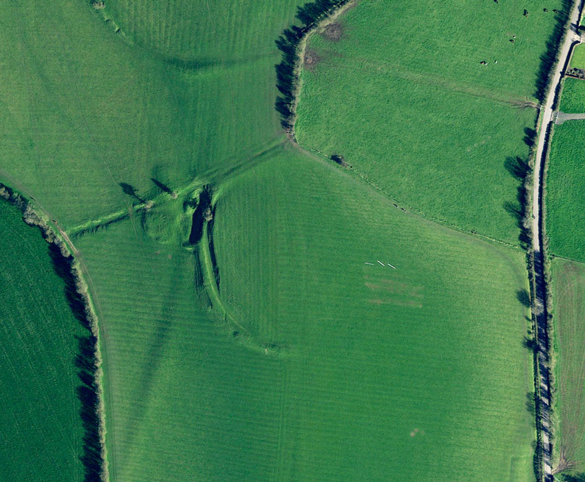
The Hill of Tara has always been a dynamic landscape in which each generation’s monuments contributed to a cultural memory informing the placement of newer structures. It remains a dynamic landscape for archaeologists and historians due to the discoveries enabled by new technologies. But it most contentiously remains dynamic on the political and economic front, where the Battle for Tara is not about kingship but about the definition and ownership of heritage. We’ve noted above the symbolic conflicts that mutilated the Rath of the Synods, and inspired the attack on the Lia Fáil. But the battle over Tara and the M3 motorway is one that brought, in Rob Vance’s phrase, “thousands to its rampart, defending against the mohair-suited Firbolg of today.”148 Thus there is no better illustration of the passions bubbling beneath the green hill’s tranquility than the 2003 decision that allowed the National Roads Authority149 to construct a major toll highway (M3) in the Tara-Skryne Valley, with an interchange only 1.76 km (1.1 mi) from Tara’s Ráth Gráinne (see satellite view below, right).
The route of the Clonee to Kells segment of the M3 (completed in 2010) was designed to replace the N3, the link from Dublin to the northwest, which runs through the valley to Tara’s east.
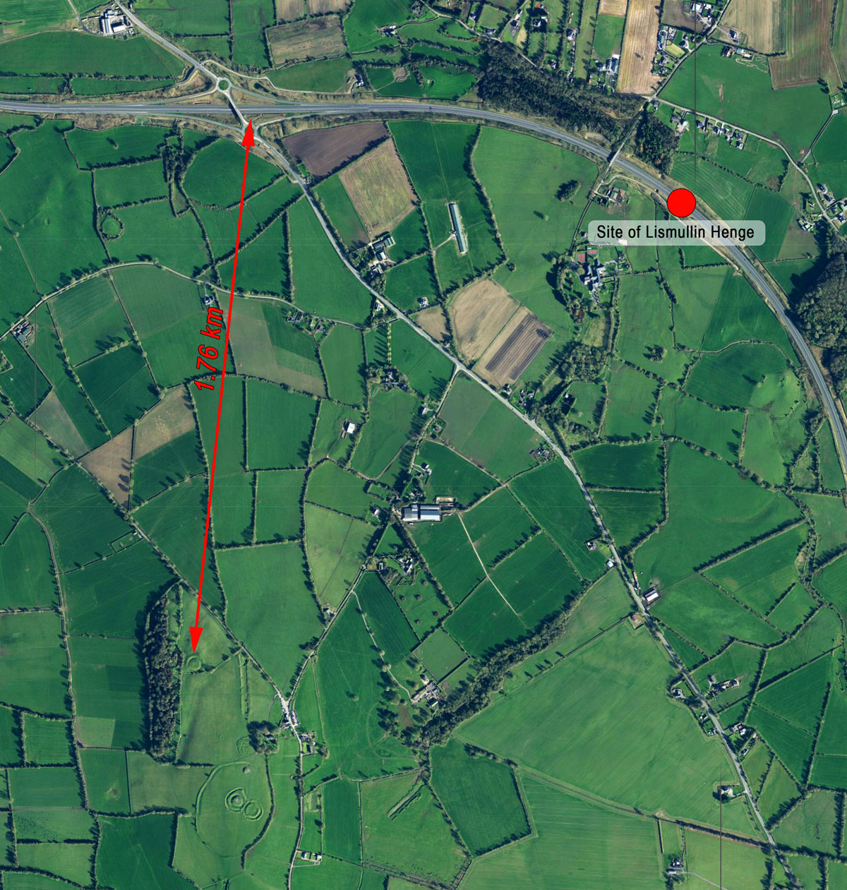
The distance between Tara and the M3.
Road improvement is not entirely a modern notion, as archaeologists have uncovered evidence in a bog demonstrating that parts of this ancient pathway were “improved” with logs covered in gravel.150 Many in the affected area insisted that the M3 was necessary to relieve congestion; it was promised to reduce by 30 minutes the commuting time between Dublin and Cavan. One local resident was quoted as saying, “…the motorway is needed. We no longer live in thatched cottages, no longer drive donkeys and carts. That’s the reality.”151
Others, however, including environmental activists, historical preservationists, and some of the country’s most prominent archaeologists were adamantly opposed to the road’s proximity to the Hill of Tara. A survey in 2008 indicated that nearly two thirds of Irish adults wished for the government to consider an alternative to the route through the valley. But a 2004 law provided the authority to pave over a national monument, once excavation was completed, if it were deemed “in the public interest.”152 In a gesture to satisfy its critics, the government in 2009 proposed that the Tara-Skryne Valley be designated a “Special Conservation Area,” in order to avoid the rampant development which elsewhere accompanies new motorway construction with “big box housing developments, strip malls, superstores and suburban sprawl.”153
“The M3 will cut right through this landscape; and all the sites destroyed in its path are an integral part of Tara. It is not academics who have defined this landscape, it is the people of the past: this is their testimony.”
…
“If Tara is a symbol of our national and cultural identity, this roadway will stand as a permanent monument to a loss of direction, meaning and identity.” 154 (Edel Bhreathnach, Joseph Fenwick and Conor Newman)
It seems that also aligned against the construction of the M3 was the world of the Sidhe. An activist named Carmel Divine claimed that a “modern day Curse of Tara”155 was loosed upon the land by the construction of the motorway on land belonging to the fairies. Divine listed a number of unfortunate occurrences as evidence of the curse, including the fact that Martin Cullen, then the Minister for Transport, was nearly sucked out of his helicopter when its door mysteriously fell off mid-flight.
Other anti-motorway activists were cut from similar cloth, prompting Stuart Rathbone, a field archaeologist working on the M3 right-of-way excavations, to call some elements of the “Save Tara” movement “a confederation of neo-pagans, hippies, enviro-Mentalists and other gobshites…”156
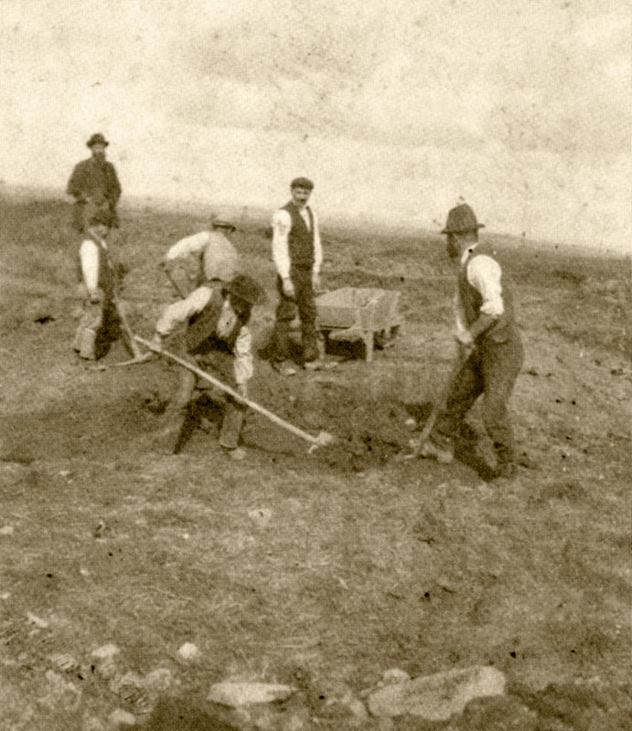
Due to the extent of its prehistoric settlement distribution, there are few areas in Ireland “where major construction operations will fail to reveal substantial numbers of archaeological sites.”157 Also, as a result of the national—and international—attention focused upon the controversial project, the excavations were conducted “with seemingly limitless budgets.”158 Therefore, the one outcome that perhaps all sides would applaud is that the archaeological work completed along the route of the M3 was first rate and resulted in some exciting and previously unknown discoveries.
The most significant of the discoveries was a timber henge, or circle, found directly in the path of the M3 in the townland of Lismullin 2.36 km (1.47 mi) northeast of the Mound of the Hostages.159 This .5-hectare (1.2-acre) enclosure of two concentric circles was built of small wooden posts set within a natural amphitheater. It was dated to the Early Iron Age (520-370 BCE). Likely associated with the henge was a row of pits within the inner circle. These held bone fragments from the Neolithic Period.
In their report on the excavations along the route of the M3, archaeologists Mary B. Deevy and Donald Murphy discussed the pits at the Lismullin Henge:
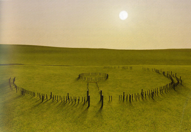
Illustration of Lismullin Henge.
“The overwhelming impression of these pits is that they are of a ritual nature. The location of this activity is at a point in the landscape that would have had a clear line of sight to…the Mound of the Hostages…”
…
“This may be an indication of culturally similar, small-scale ritual activity. The Neolithic pits at Lismullin are…broadly contemporary with the use of the [Mound of the Hostages] passage tomb, which would have been a significant visual reference… “ 160
It is likely today that very few of the 3,000 motorists each day passing directly over the Lismullin henge are aware of what lies buried beneath the concrete of the motorway.161 The discovery of this site would seem to provide a validation of the motivations, if not all the actions, of those who insisted that the construction of the highway would forever hobble future efforts to understand the extended ritual landscape of the Hill of Tara.162
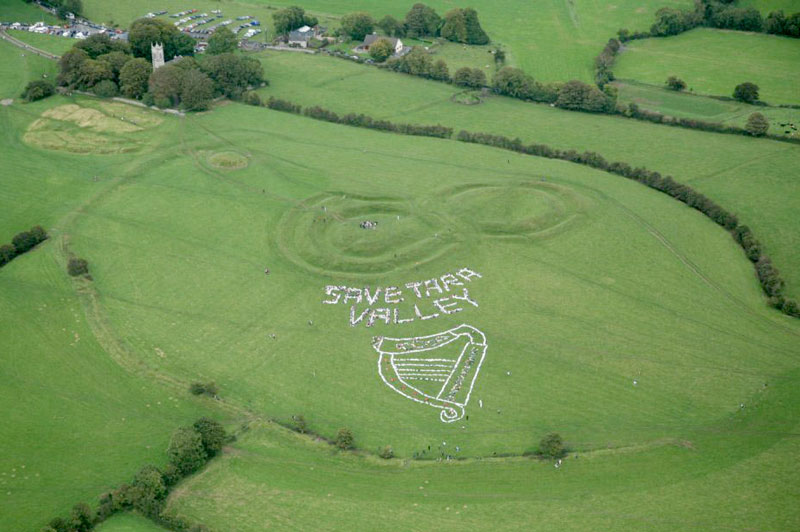
Protestors formed an image of a harp at Tara on September 23, 2008.
The folklore of the Hill of Tara is a story still being told. While the Irish Independent on September 24, 2008 claimed that “over 3,000 people posed for an unprecedented aerial shot…” of their human-formed image of a harp on the Hill (see photograph at right), the truth, according to one participant, was that there was about a third that number present; this is modern folklore.163
For a time, the interest in all things Tara gave birth to well-attended festivals and communal events. But even though the M3 has made travel to the Hill from Dublin less time consuming, the celebratory events, paradoxically, seem to have faded away in the ensuing years. The Tara Celebrations site, however, remains online.164
However, the subtle but compelling spell cast by the Hill of Tara continues to draw callers from all over the world to its monuments. These visitors respond to the stories told here through both science and myth. There are the busloads of tourists who look in vain for impressive above-ground ruins, the local dog walkers, the rough-campers who claim ownership through royal lineage, the earnest ley-line enthusiasts, the persistent British Israelites, the genealogy searchers, the farmer harvesting his hay, and the visitors from near and far trying to make sense of it all.
“For about the last six thousand years, each generation has made its mark on Tara and has itself received something in return from the phenomenon that is Tara.” 165 (Conor Newman)
Click here to see all the notes from this page.
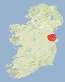
The Hill of Tara, Co. Meath
Nearest Town: Navan
Townland: Castleboy
Latitude: 53° 34′ 45.67″ N
Longitude: 6° 36′ 39.72″ W
Many thanks to those who assisted in the editing of this page: Elyn Aviva, Michael Fox, Ronald James, Joan Revington, and David von Seggern.