21 Nov The Hill of Uisneach
“The history of Ireland might be written from the hill-top and the ruined palaces of Royal Uisneach. Though its glories are faded and gone, and its hosanna long silenced in the solitude of time, those who visit it will see striking evidence of its former greatness. Though ruin has filled the scene with the fragments of its ancient splendour, the great men who dwelt here and ruled the people of Erin are not forgotten, though nearly two thousand years have rolled over since Tuathal, the Acceptable, as the renowned king is called who built the palace in the first century, sat upon the coronation chair on Royal Uisneach.”
James Woods Annals of Westmeath, Ancient and Modern, 19071
Click the image above to enter the virtual-reality tour.
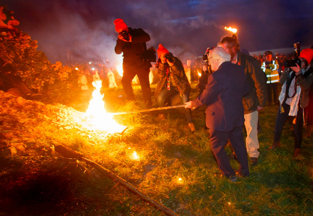
President of Ireland Michael D. Higgins lights the Uisneach Bealtaine fire in 2017.
Of all the Hills in Ireland where legends speak of a celebrated óenach (gathering or fair), several have seen a modern attempt at reviving the practice. In Teltown, for example, the 1924 and 1964 Olympics-styled revivals of the legendary Óenach Tailtiu each lasted but briefly. A more recent 2013 effort to resurrect the assemblages on the Hill of Tara quickly faded away. 2
But at the Hill of Uisneach, the 2009 revival of the Bealtaine Fire Festival is an ongoing and vibrant óenach, combining aspects of Celtic tradition and new-age spiritualism, all within the exuberant ambiance of a rock festival. As its website proclaims, “The Bealtaine Fire Celebration on the Hill of Uisneach is a genuine gathering of the tribes; people of all creeds, from all over the world coming together with the local community to create a truly unique event.”3
Mythology, Folklore, and Archaeology on the Hill of Uisneach
While there can be no doubt that the modern Bealtaine Fire Celebration is real (the many videos online will attest to that), scholars have differing opinions as to whether or not the Hill of Uisneach was the site of an important gathering or óenach4 in the distant past. D.A. Binchy, writing in 1958 was unequivocal:
The ‘Assembly of Uisnech’ can be quickly disposed of. There is not a shred of reliable evidence that any such assembly was ever held throughout the entire historical period. And even among the legendary sources we find only two attempts to describe it, both of them very late.” 5
In the feature to the right you can explore the Royal Palace (Conjoined Ringfort) as imagined by illustrator JG O’Donoghue.
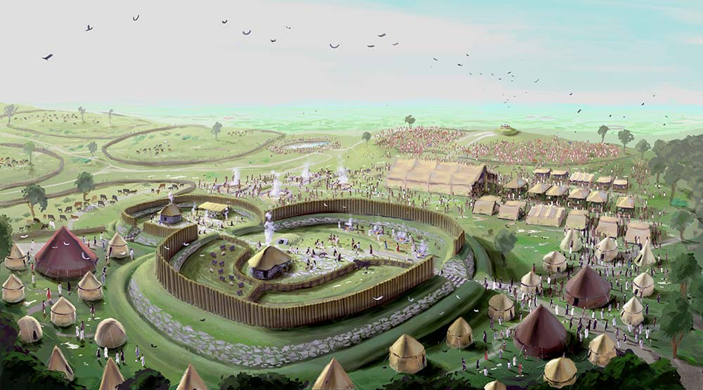
Click the image above to explore the illustration of the Royal Palace.
However, a much more positive view is expressed by Rosanne Schot, who writes (2011), “…there is an impressive body of evidence to support the identification of Uisneach as a place of assembly.” Schot points to what may have been an assembly space around the summit mound of Carn Lugdach. She suggests that religious ceremonies there may have formed the basis of the stories of an óenach at Uisneach.6
Also, from the perspective of Irish mythology writ large, Schot embraces the “Voices from the Dawn” metaphor that acknowledges the prehistoric threads lying deep within the tales:
“…historians and literary scholars by and large agree that despite ‘censorship, revision and deliberate omission’ on the part of Christian redactors, some residual motifs or themes of pre-Christian origin remain.” 7
The Hill of Uisneach can claim a connection to most of the major figures of Irish mythology, including Lugh, Ériu, the Milesians, the Tuatha Dé Danann, the Dagda, and even Fionn Mac Cumhaill. This inclusive Irish pantheon, however, may be a later reflection of the centrality of the Hill in the dynastic politics of third and fourth-century CE Ireland.8
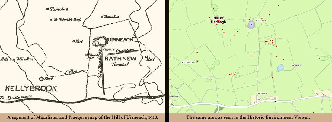
The Hill of Uisneach from the 1928 excavation, and as seen in the Historic Environment Viewer.
In addition to the gods of mythology, the legendary landscape of Uisneach includes a visit by St. Patrick, which did not go so well (see below). Brian Boru is said to have occupied the hill briefly.9 A more permanent resident, however, was the quasi-historical 2nd-century prince Tuathal Techtmar, said to reside in the Royal Palace, the conjoined ringfort featured in our virtual-reality tour. Other legends connected to the site proclaim its position as the center of Ireland (if not of the cosmos; the axis mundi), and that the initial division of Ireland into five provinces radiated outward from the most prominent stone on the Hill of Uisneach, the Stone of the Divisions, featured below.
“Countries have their factual and their mythical geographies. It is not always easy to tell them apart, nor even to say which is more important, because the way people act depends on their comprehension of reality, and that comprehension, since it can never be complete, is necessarily imbued with myths.” Y.F. Tuan, 1977 10
Rather than attempt to explore these notables of myth and legend at Uisneach all at once, we will deal with each separately below, as we discuss the relevant archeological feature on the Hill. In this way, the stories can be woven into the facts on the ground.
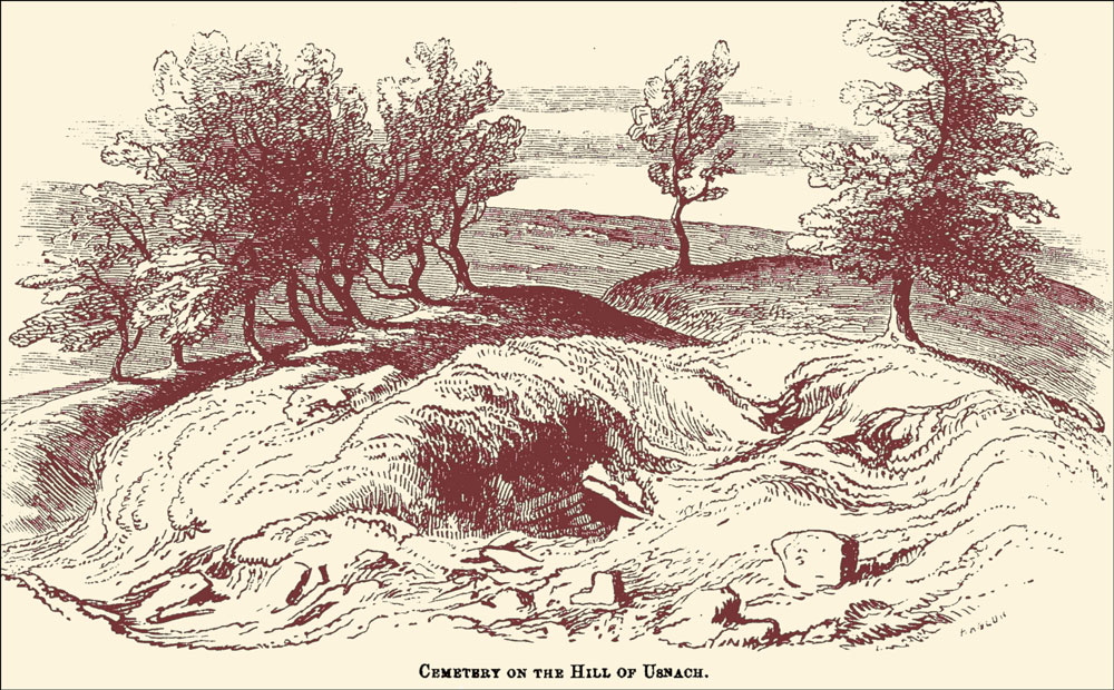
The Eastern House at Uisneach was for many years thought to be an ancient cemetery.
The “facts on the ground,” however, have themselves undergone very different interpretations over the years. The pioneering scholar John O’Donovan, surveying the Hill of Uisneach in 1836, claimed that parts of the massive glacial erratic, the “Stone of the Divisions”, formed a portal tomb. He thought it was “a splendid cromlech” on which “the Pagan Irish did offer sacrifices.” Later observers, of course, beginning with William Borlase in 1897, saw nothing of the sort.11
Samuel Ferguson (1879), T. J. Westropp (1901), and their contemporary antiquarians, were confident that what we know today as the “conjoined ringfort” was in fact the ancient Uisneach cemetery of legend. Later excavations found no evidence of a cemetery.12
The modern archaeologists who subsequently investigated the Hill were clear in making a distinction between their work and that of their predecessors. In his report on his excavations, R.A.S. Macalister (1928) harshly disparaged O’Donovan’s work:
“…it becomes immediately obvious that O’Donovan’s indications of compass-bearings must be ignored; they seem to be written from an imperfect recollection of faulty observations.” 13
The God Lugh.
Macalister, along with R. Lloyd Praeger, spent five years digging within the conjoined ringfort.14 From their excavations, they concluded that the enclosure represented four different phases of occupation, beginning in the Bronze Age with a ceremonial enclosure, and then with three different domestic phases, continuing to about the third century CE (La Téne period).
A couple of generations later, when Roseanne Schot (2006) took her modern archaeologist’s sensibilities to Macalister’s excavation report, she noted that Macalister’s “…investigations were neither carried out nor reported on to a modern standard….” Citing his incomplete field notes and missing stratigraphic information, she concludes that Macalister’s assumptions regarding the timeframe of the remains on the site were faulty. She wrote:
“[Macalister’s] chronological framework was clearly fashioned to accord with the traditional ‘historical’ narrative promulgated by medieval pseudo-historians, and was particularly influenced by the work of Geoffrey Keating who composed an elaborate account of the Beltaine assemblies reputedly celebrated at Uisneach in ancient times…” 15
Schot’s reexamination of Macalister’s excavation has suggested that the site is neither as old as Macalister and Praeger believed, nor did its use end when the excavators proposed. Schot concludes that the first occupation was in the Late Iron Age (fourth-fifth century CE), not the Bronze Age. The third century CE, which Macalister believed concluded the story of Uisneach, may actually mark the beginning of a long period of occupation and structural activity extending into the Medieval period, according to Schot. For a chart that compares Macalister’s and Schot’s differing timeframes for this site, click here.
Of course, it must be noted (although it’s obvious) that Schot could not know Macalister and Praeger’s thinking when they came to the conclusions they did in 1928; nor are the excavators present today to refute any of the observations Schot made regarding the accuracy of their work or their motivations.
The Monuments
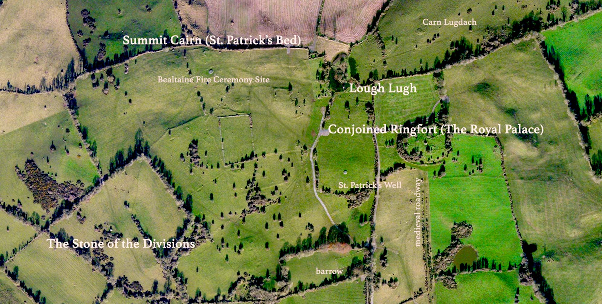
We will consider each of the main monuments on the Hill of Uisneach in the order they would be encountered on a tour of the site, which is the only way it may be visited. The combination of geophysical tools and traditional excavations have identified more than 40 archaeological features on the Hill of Uisneach, embodying a history of some 5,000 years.
In this virtual-reality environment we explore four monuments in detail, within 16 different VR nodes (locations), captured from both ground and aerial positions. These four monuments are: the Conjoined Ringfort (Royal Palace); Lough Lugh, the Summit Cairn (St. Patrick’s Bed); and the Stone of the Divisions (the Catstone). Information labels are derived from the report of the 1928 excavation, its 2006 reinterpretation, the Historic Environment Viewer, and other sources. In addition, there are nodes which superimpose some of Macalister’s excavation diagrams upon the VR landscape. Each of the monuments will also be featured in the text below.
The Conjoined Ringfort
“It should be remembered that a king was as much a religious as a political functionary in antiquity; and when king Tuathal crossed the Shannon and sought a dwelling for himself, it would seem to him right and proper that he should house his sacred person in a traditional sanctuary….Traditional taboos were enough to protect the sanctuary from violation; but the king needed walls of stone to supplement the invisible walls of superstition. Therefore we now find strong ramparts running over soil which contains the tangible remains of earlier feastings.” R.A.S Macalister 16

Bronze Pin with Silver Inlay
The Conjoined Ringfort, also known as the Rathnew Enclosure, is arguably the most significant archeological feature on the Hill of Uisneach.17 The site is more romantically referred to as the “Royal Palace.” While inferences from the site’s legendary occupants may make the regal address plausible, the excavation (1925-1930) uncovered only one artifact that might be worthy of a high-status resident. This was a pin, likely a dress pin, with a silver inlay at its tip, (see illustration, left). Macalister described it as “…the pin of a penannular brooch, with simple La Téne ornament, incised and inlaid with silver…” 18 Roseanne Schot, however, concluded that the pin more likely belonged to the 6th or 7th century C.E., which further casts doubt upon Macalister’s timeline for the fort.19

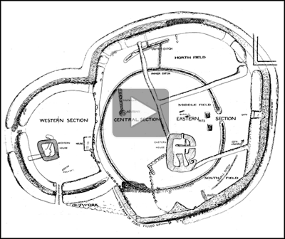
The Conjoined Ringforts
Long before the Royal Palace, perhaps 400 years earlier, the site was used for a different purpose altogether. Excavation revealed evidence that, during the late Iron Age, the eastern part of the hilltop was a ceremonial site, a place where the rituals enacted must forever remain a mystery. Oral traditions reflecting memories of this usage may have prompted a local chieftain, many generations later, to choose this hill for his “Royal Palace” earthworks. According to Schot, “…there is strong reason to suspect that the Phase I ditch still retained a physical presence, however slight, when the earthworks were erected.”20
The ceremonial site, a 50m ditch making a nearly-complete circle, dates from a period between the 3rd and 5th centuries CE. The ditch has pits and postholes in its interior, some of which may indicate a roofed structure. However, a more reasonable explanation for the pits is that they were used for ceremonial offerings, as quartz pebbles found in one of the pits may be connected with ritual activity. Many of the pits were found to contain burnt animal bones, perhaps ritual offerings.21 With a leap of the imagination, Macalister wrote that the ditch was “…strongly suggestive of a sanctuary-site, in which fire was kept burning perpetually, or kindled at frequent intervals….”22 Macalister may have been inspired by Uisneach’s association in folklore with a druidic fire cult and the traditional Bealtaine celebrations, during which the lighting of the fire on the Hill of Uisneach would signal the moment when fires were to be lit all throughout the land.23 Both Macalister and Schot thought that the site may have served as a “liminal site” (a transitional space between the sacred and the profane) and as a ceremonial sanctuary.24 It is likely that a sustained folk memory of this sanctuary was a determining factor for the builders, four centuries later, of the “Royal Palace.” As Roseanne Schot wrote:
“…the construction of the impressive conjoined ringfort of Rathnew…must be understood in a context in which the ritual of kingship was rooted in a pagan past and legitimacy was gained by harnessing the power and significances invested in ancient places.” 25
Click to view an animation with Macalister's photograph of the excavated Eastern House superimposed on the site as it appears today.
The “Royal Palace,” with its conjoined ringfort, was thought by Macalister after his excavation to represent two distinct phases of construction and occupation. The larger Eastern Enclosure, with its complex house construction, was thought to be earlier, followed some years afterwards by the Western Enclosure, which he called “a subsidiary accretion.”26 Schot’s examination of the excavation data, however, led her to conclude that the two enclosures of the conjoined ringfort were constructed at the same time.27 Macalister, in another leap of the imagination, suggested that the circular depression surrounding the enclosure would “…be very suitable for horse or chariot races (such as we know were held in ancient Ireland) which might be viewed conveniently from the central enclosure.”28
There is no evidence, other than the spinning of myths into pseudo-history, to confirm that the Royal Palace was the home of the legendary King Tuathal Techtmar, from the second century CE. However it was clear both to Macalister and to Schot that the site was appropriated as a royal seat by the southern Uí Néill, and the structures they built “suggests evidence of high-status occupation…between about the late seventh/eighth century and the eleventh century AD, with some indications of later activity extending into the medieval period.”29
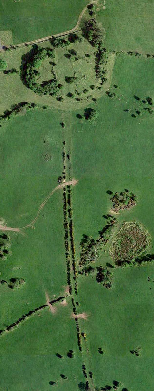
Ancient Roadway (Google Maps)
Visitors today who make the trek up to the Rathnew Enclosure should be sure not to miss the view to the south, where in the valley below they will note a distinctive tree-lined roadway approaching the hilltop where they stand. Their guide may even point this out to them as a “processional avenue” which the king and his entourage would use to enter the Royal Palace. When excavated, it was shown to have been embanked with a drystone wall on either side This roadway may be seen in a satellite view to the right, and here in a virtual-reality view from 18 m (59 ft) above the ringfort. It was the excavators of the site in 1928 who first imagined this processional cursus, as they concluded that the avenue extended deep into the ringfort, and blended with the wall separating the Eastern and Western Enclosures. They reported that “Local gossip asserts that the roadway… ultimately makes its way to Streamstown,”30 though they found no evidence of this on the ground. If this “gossip” (or folklore) were true, the “processional avenue” would have been a 5.38 km (3.34 mi) route to the palace. In reality, the avenue is but 500 m (1640 ft) in length. Macalister and Praeger inferred much of their proposed timeline for the site based upon their interpretation of the avenue.
Roseanne Schot, however, examining the excavation report 78 years later, had a very different conclusion. While admitting that there was a possibility she may be in error, she strongly suspected that the “…so called ‘ancient roadway’ may be one of latest monuments constructed at Uisneach.” She observed that the roadway terminates 40 m (131 ft) to the south of the enclosure, and concluded that was likely constructed during the medieval period.31
It is however hardly necessary to describe at length the process of the excavation of this building and of the gradual revelation of its complexities; the work, from the first almost to the last, was a constant series of puzzles and surprises.” 32 R.A.S Macalister, 1928
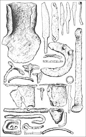
Click to open a new window with an interactive feature exploring the manufactured objects found during Macalister's excavation.
The items discovered during the five years of excavation at the Royal Palace were most remarkable for what they did NOT include: pottery. As Macalister put it, “From the moment of this initial observation we watched specially and continuously for pottery; and we are in a position to state that not a single particle of this material was detected…” While suggesting that the absence of pottery may have been due to a “religious taboo,” he allows that there may be a simpler explanation: a preference for leather or wooden containers.
While there were only a few fragments of human bones unearthed, animal bones discovered included the partial skeletal remains of at least five large dogs, which may represent a “wolf-like” ancestor of today’s Irish Wolfhound.33
In her own assessment of the excavators’ finds Roseanne Schot noted that discrepancies in the report regarding the number of objects, and “the near complete absence of contextual information” made Macalister’s interpretations of the finds problematic.34
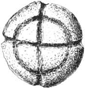 Schot identified two objects in the collection that she deemed prehistoric. One was a sandstone ball, 5 cm (2 in) in diameter (right). The ball was incised with a simple decoration of grooves intersecting at right angles.35 The other was an object dated to the Roman Iron Age, (2nd to 4th century CE), a barrel padlock key. Amazingly, according to Schot, the only known lock in Ireland that would potentially match this key was one found at the Rath of the Synods at the Hill of Tara. Most of the remaining artifacts, according to Schot, may be dated to the 7th to 11th centuries CE. We’ve created an interactive feature from Macalister’s three composite drawings of his finds.
Interactive Excavation Diagram.
Click to open in new window.
During their excavations at the hilltop conjoined ringfort, Macalister and Praeger discovered evidence of houses, walls, ditches, doorways, guard chambers, souterrains, heaps of ashes, burials, and postholes. Rather than describe these here, we have created an interactive feature which brings together Macalister’s drawings with his photographs of the excavated Eastern House. Click on the image to the left to load this interactive into a new browser window; click the “full screen” icon at the right of the toolbar for the best detail.
The same drawings created by the excavators have been incorporated as overlays in the virtual-reality feature at the top of the page. These may be accessed directly for the entire Rathnew Enclosure, for its Eastern House, and for its Western House.
In a further effort to bring a new audience to the excavations of Macalister and Praeger, the image gallery below presents their photographs and drawings of the excavation and its findings.


Lough Lugh
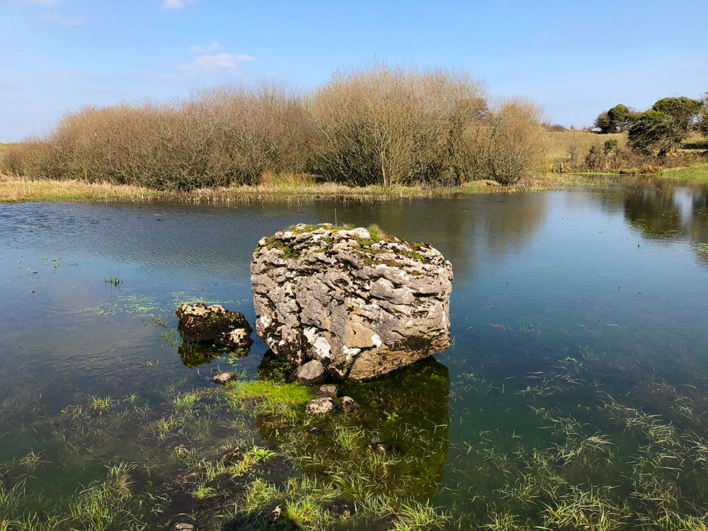
Lough Lugh
If you have had the opportunity to view Lough Lugh, a large pond fed by an underground spring, in the comprehensive VR feature above (available directly here), you will have noted that it lacks an essential feature of a lake; namely, water. In our aerial VR panorama, photographed during the dry summer of 2018, the 60 m by 80 m (197 ft by 262 ft) lake had not a drop to be seen. Presumably, in the mists of legend, there was a sufficient water in the eponymously-named lake for the pre-Christian deity Lugh to meet his demise there by drowning.
Fortunately for the viability of legends, climate scientists have determined that the lake has had episodes throughout its history in which it held no water. Core samples have suggested that, in at least one case, the inhabitants dug out the silt-filled lake to allow it to again fill with water.36
The legend of the lake comes from the 11th-century Dindshenchas (Lore of Places), much of which was compiled from earlier traditions. It claims that Loch Lugborta (Lough Lugh) was so named because Lugh, warrior-god of the Tuatha Dé Danann, was drowned in the lake during an assembly on the Hill. Lugh was trying to escape from three divine brothers named Mac Cuill, Mac Cécht and Mac Gréine who were pursuing him because he had killed their father. The three brothers ran a spear through Lugh’s foot before drowning him in the lake. This may have been the end of Lugh, who had ruled for 40 years, but not the end of his influence within Irish myth. His son was Cúchulainn, the fabulous hero of the Táin Bó Cúailnge, whom we discuss elsewhere.
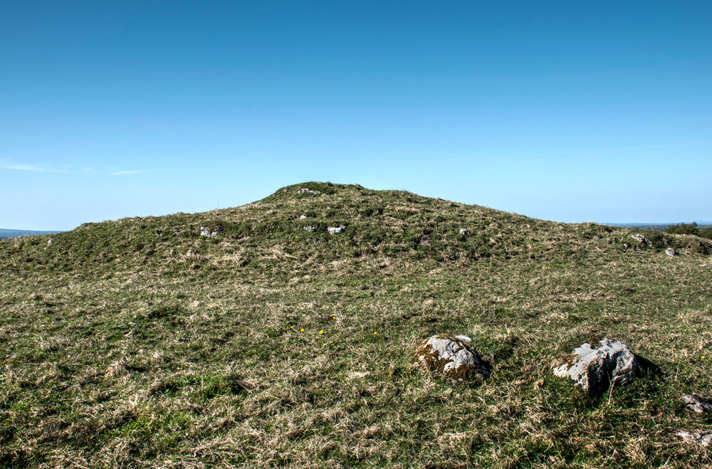
Carn Lugdash
Following the battle, the Dindshenchas claims, Lugh was buried in a cairn just to the northeast called Carn Lugdach. This site, 20 m (66 ft) in diameter, is shown in the photograph to the right. Macalister dug a trench through the cairn, but found nothing. He reported, however, that he “…heard a story that this mound had been violated in comparatively recent times, and that a cist [burial chamber] had been found within it; but if so, it was utterly demolished.”37
Roseanne Schot proposed that Carn Lugdach might be a bowl-barrow dating from the early Bronze Age, and goes on to suggest that the mound may have played an important role in royal ceremonies at Uisneach during the early medieval period. The site has not been excavated in the modern era. But a geophysical survey in 2005 revealed a complexity of sub-surface features, including an enclosure “truly monumental in scale” surrounding the whole of this summit of the hill, some 200 m (656 ft) in diameter. 38 If Carn Lugdach is ever properly excavated, it may prove to eclipse the Royal Palace as the most significant monument on the Hill of Uisneach. As Dr. Schot notes,
“The prominence of Carn Lugdach within this discrete group of monuments raises the distinct possibility that it served as the inauguration mound of the kings of Uisneach – the final destination, perhaps, in a royal procession that also took in other significant monuments such as the Cat Stone.” 39
The Summit Cairn (St. Patrick’s Bed)
St. Patrick’s Bed
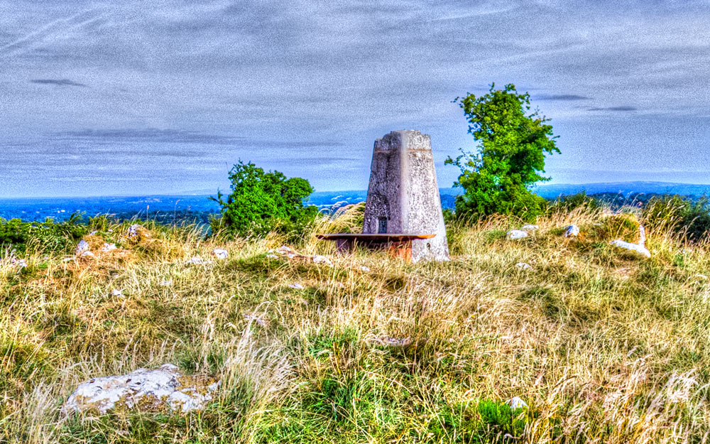
The western summit, the highest point on the Hill of Uisneach at 180 m (591 ft), offers one of the most storied viewscapes in Ireland. It is said that from this spot, on a clear day, the view extends to 20 counties. Macalister wrote that “Beacon-fires, lit upon its summit, could be seen over a quarter of Ireland.”40 It may be that such fires marked the beginning of a springtime tradition that has today become the modern Bealtaine Fire Festival. For a drone’s eye view of this storied panorama, click here.
Crowning the summit today is the dilapidated stone structure known as St. Patrick’s Bed, where the most pronounced feature is a bleak cement Ordnance Survey station. In 1837 John O’Donovan heard from locals that the site “was much more perfect before the sappers [British troops] removed the stones from it…” to create the survey station we see today (see photo, above left).41
However, stones scattered all about the low mound of the cement survey station suggest the site was a far more important location in prehistory. While the now-disorganized stones of this grass-covered cairn make its exact classification difficult, Schot writes that it “…is likely to represent the remains of a megalithic tomb of one type or another.42 Completely invisible to a visitor to the site today are the two overlapping circular disturbances in the earth below, discovered using geophysical instruments. These circles may be the remnants of ritual enclosures, defined by wooden palisades. Click here to see the two circles superimposed on an aerial VR view of the site. This site may be the oldest archeological feature on the Hill of Uisneach.
The name of the site, St. Patrick’s Bed, was first recorded by John O’Donovan, and may have reflected legends of the saint’s visit to the Hill. One such story, from the Tripartite Life of St. Patrick, relates how the saint came to Uisneach and established a monastery on the Hill. Some local tribal leaders, however, refused Patrick’s offer of mutual respect, and the saint was soon expelled. Patrick then uttered a curse against “…the stones of Uisneach, and from that [day] out they have not been of any use…”43 The stone that may have been the target of Patrick’s curse, the Stone of the Divisions, is featured below.
St. Patrick’s name was also attached to another feature on the Hill, according to O’Donovan. Noted on the satellite view that begins our VR tour is St. Patrick’s Well. This spring, and perhaps the squat upright stone beside it, “may have been imbued with a ritual significance in antiquity.”44
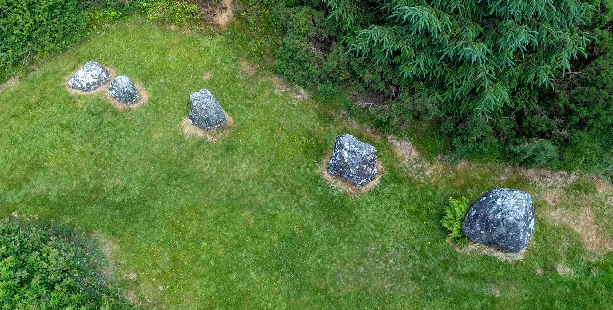
The Stone of the Divisions (the Catstone)
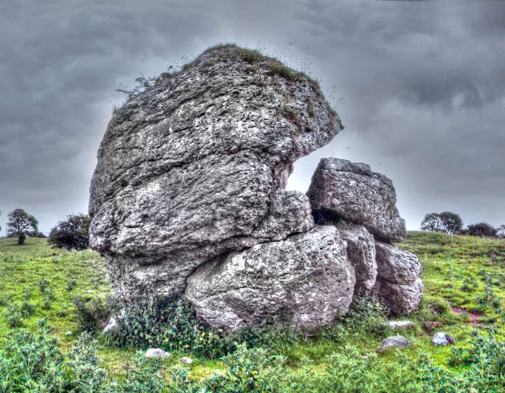
Can you see a cat about to pounce on a mouse?
How can a natural stone be considered an archaeological monument? The Stone of the Divisions (Ail na Míreann) is a large glacial erratic, which, due to its size, must have attracted attention to itself from the beginning of human habitation on the Hill. The rock is also known as the Catstone, a name which may be explained by the photograph to the left. Although John O’Donovan claimed to see a dolmen (portal tomb) within its structure, the stone has not been altered by human interference, save for the hole drilled into the top of the boulder for a flagpole (see photograph below, with Éamon de Valera).45
Another traditional name for the 5 m (16 ft) wide, and nearly as tall, stone is Umbilicus Hiberni (the navel of Ireland). It was, according to the credulous Giraldus Cambrensis (12th century), considered the geographic center of the island. Taking it a step farther, it was thought by some to be the Axis Mundi, or center of the cosmos. As archaeologist Carleton Jones put it:
“These traditions come down to us from Early Medieval and Medieval sources but as with mountains and rivers, the uniqueness of the boulder and the uniqueness of the hill on which it sits makes it the sort of natural feature that Mesolithic people would have probably assigned meanings and stories to.” 46

Éamon de Valera (right) atop the Catstone.
As for the role of the Catstone in the overall significance of the Hill of Uisneach, R.A.S. Macalister put it succinctly when he wrote that the stone “…undoubtedly attracted attention in ancient times; but it may be left an open question whether the stone consecrated the hill or the hill consecrated the stone.”47
The only photograph we have of the Catstone being used as a speaker’s platform is from 1926, when Fianna Fáil leaders Éamon de Valera and Seán Lemass addressed a crowd from atop the stone (right).48 Thirty-one years earlier however, Jack Stokes, as a young lad of seven, witnessed a similar scene:
“In 1895 a great demonstration was held by the United Irish League on Uisneach Hill, near the Catstone. I went, with other lads, to see it and to hear the bands. I saw John Dillon making his speech, John Redmond and many other M.P.s were there too. It was the biggest crowd ever in Westmeath… At that meeting…thunderous resolutions condemning landlordism and British Government were passed.” 49
Even earlier, in the 1840s, one of Daniel O’Connell’s “monster meetings” for Catholic emancipation was said to have taken place on the Hill. It’s highly unlikely that these modern demonstrations to assert an Irish identity marked the beginning of the Catstone’s use as a political stage. One can imagine a local chieftain striking a pose similar to de Valera’s from the same perch atop the stone hundreds or even thousands of years earlier.
Although the Catstone is a natural feature, the stone and the low earthen ring that encloses it comprise a listed national monument. Classified as a type of barrow, the enclosure is around 24 m (79 ft) in diameter. One theory is that the ring was created in response to the reputation of the Catstone, or perhaps as a place to deposit the earth removed to expose the lower parts of the stone.
A more fanciful explanation of the enclosure suggests that it was created to make a physical representation of a human navel,50 a visual metaphor with a stone “outie” that may be noted in the photograph, below right, or here in our aerial VR viewpoint.

The Catstone and its enclosure resemble a navel.
Roseanne Schot interprets the enclosure to have a potential date-range from the later Neolithic all the way into the first millennium CE. She further states that “…the site appears to be unique in Ireland in the sense that it is, as far as I am aware, the only enclosure of its kind to incorporate a massive, glacial erratic at its centre.”51
The Stone of the Divisions, in tradition, represents a symbolic centrality, and was depicted in early lore as being within the “fifth province,” called Míde (Meath) meaning “middle.” The stone was considered to be the meeting point of the five ancient provinces of Ireland.52 Of course, modern Ireland has only four provinces; but a vivid explanation of this “fifth province” may be found here. The massive stone was also thought to mark the burial of Ériu, the goddess of the Tuatha Dé Danann whose name in modern Irish, Éire, became the name of the country.53
“The Fifth Province is not anywhere here or there, north or south, east or west. It is a place within each one of us – that place that is open to the other, that swinging door which allows us to venture out and others to venture in.”
Mary Robinson on her inauguration as President of Ireland, 3rd December 1990.54
The Modern Bealtaine Fire Celebration
Why has the modern revival of the Bealtaine Fire Celebration at Uisneach been such a resounding success while attempts at such revivals in other historic venues (see top of page) have failed? Perhaps the most significant reason is the enthusiastic approval and participation of the landowners, David and Angela Clarke, within whose large working farm much of the Hill of Uisneach is located. Significantly, the Clarkes tend not only the land, but being thoroughly modern agrarians also manage the uisneach.ie web domain (uisneach.com is a bit more enigmatic).
David Clarke and his daughter Denise even made an appearance in a RTE video of the 2020 pandemic-reduced Bealtaine event. By working with the State and other concerned parties, the Clarkes have created for the monuments on the Hill of Uisneach a curated visitor experience, with only guided tours allowed, and with pathways to the monuments bordered by visually discreet fencing to separate the visitors from the livestock. Each visit concludes with a tea and a chat in the Uisneach Heritage Centre at the bottom of the hill.
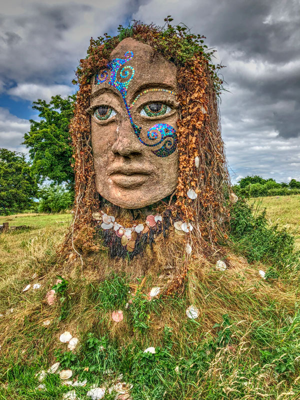
The Goddess Ériu.
Another reason for the continuing draw of the Hill of Uisneach Bealtaine event may be because the spectacle of its fire is so mesmerizing. Flames may in some circumstances be frightening, but in a controlled environment the ritual bonfire is enchanting, awakening hereditary memories of celebration, warmth, and the comfort of home, as well as a glimpse into the fire of cosmic creation.
The Bealtaine Fire Celebration is a joyous coming together of the tribes, Celtic and global. It is a colorful concoction of fire dancing, drum circles, yoga, druidic dress-up, and mounted processions. There are charioteers and jugglers, food, music, crafts, and dancing. The are robed representations of Lugh and Ériu, Fionn Mac Cumhaill and Brian Boru, and of course the King of the Royal Palace, Tuathal Techtmar.
Certainly, in the scheme of things, the modern revival of the Bealtaine event occupies but a brief moment in the long history of the Hill of Uisneach, which reaches back into the Neolithic. The longevity of the current óenach revival depends on factors as mundane as the inclinations of any future landowner, and as global as a disruptive cultural realignment resulting from climate change.
In some ways the Bealtaine scene on the Hill may seem similar to any such large-field festival elsewhere in the world. Across the pond, in the remote Black Rock Desert of Nevada, the annual Burning Man event presents spectacular fire displays to a large international crowd.55 But the Bealtaine Fire Celebration has a more defined (if imaginatively romanticized) cultural agenda celebrating Ireland’s pagan past. When the master of ceremonies welcomes the “People who come with the North Wind,” the video may seem from afar to contain echoes of Game of Thrones (much of which was filmed in Ireland). But in the chill of a May evening on the Hill of Uisneach, with some four thousand participants awaiting the lighting of the Bealtaine Fire, the moment is an enthralling communal catharsis.
“Nuadh of the Silver Hand, the king,
In these days held at Uisneach on the hill,
A great fair meeting, and the people came
And filled the plain in thousands, and the chiefs
Were all assembled there, and not a man
Of the De Danann race of any mark,
But showed himself amongst his fellow-men
In that great throng that thronged about the king.”
From The Fate of the Children of Tuireann 56
Click here to see all the notes from this page.
The Hill of Uisneach, Co. Westmeath
Nearest Town: Balllymore
Nearest Village: Loughanavally
Latitude: 53° 29′ 13.8372″ N
Longitude: 7° 33′ 55.5012″ W