27 Dec Fionn mac Cumhaill’s Fingers
(Shantemon Stone Alignment)
“Perhaps these monuments were places of assembly where tribes or communities met from time to time for both secular and religious purposes. I see them functioning [as] opportunities for priests to conduct sacred rites, for crops and animals to be blessed, for friends and relatives to meet and enjoy a social occasion, a market and a fair…”
Glyn Daniel, 1980 1

Click the image above to enter the virtual-reality tour.
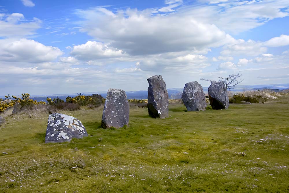
This straight row of stones, known as Fionn mac Cumhaill’s Fingers, or the Shantemon Stone Alignment, has been darkened by centuries of weathering. From the car‑park among the forestry tracks, the way is not obvious at first; but once you push through the gorse the five uprights rise abruptly ahead, their jagged silhouettes framed against the dense encroaching conifer plantation.
Archaeologists classify the monument as a stone row or alignment: five stones set in a roughly straight line, oriented northwest–southeast along the spine of the hill. The smallest stone stands at the north‑western end, only about 0.5 m (1.6 ft.) high, while the tallest at the south‑eastern end reaches close to 2 m (6.5 ft.), giving the row a graded profile as if the “hand” were rising from the turf. The arrangement is not unique—rows like this are better known in the south‑west of Ireland, particularly Cork and Kerry—but in Ulster they are comparatively rare, and the Shantemon Alignment is among the most striking examples.
The monument is usually assigned to the Bronze Age, sometime between about 1700 and 800 BCE, when small groups of tall, thin orthostats were set up on ridges and slopes across Ireland and Britain. Many such alignments cluster near stone circles or burial monuments.
")
The stones are often placed where their long axis looks outward over a broad horizon, suggesting that their builders were as concerned with distant vistas of sky and land as with what lay beneath their feet. Shantemon fits this pattern well: the stone row is just below the summit, on the north side of the hill.
The views from this spot near the summit of Shantemon alternate with each forestry generation. When the conifers have been harvested, the visitor can see the same wide horizon that may have inspired the Bronze Age community to build the stone row in this spot, perhaps to affirm their dominance of the area, or to create a ritual space with an expansive horizon.
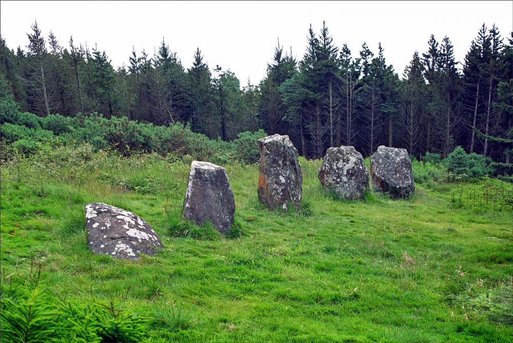
The twin photographs above show the conifer plantation cycle. The 2007 image, after timber cutting, is by Jim Dempsey.
Most visitors now will find a very different viewscape, hemmed in on all sides by regular rows of mature plantation trees, constrained in a claustrophobic tree-free rectangle barely larger than the footprint of the fingers. Every 30 years or so, after the trees are harvested and before their replacement saplings slowly change the ambiance, the view will for a few years reclaim its Bronze Age perspective.

The stones themselves are local, probably quarried from the hilltop bedrock, then levered upright into shallow pits and wedged with packing stones now hidden by turf. One, a low block slightly detached from the main line, may be a natural boulder incorporated into the design, or perhaps an upright stone that has tipped and settled almost flat. Nothing like a burial cist or cairn has been recorded at the row. Instead we are left with a vague suggestion that orientation and sight‑lines mattered here: the graded stones forming a kind of pointer or marker that once spoke clearly to people who watched the sky far more carefully than we do now.
“Funerary monuments, ancestors, gatherings, and territoriality coalesce in the assembly landscapes of early medieval Ireland.” 2
Elizabeth FitzPatrick, 2015
Astronomical interpretations have been proposed for many Irish stone rows, and Shantemon is no exception. The northwest–southeast axis would allow the row to register the setting or rising positions of certain bright stars or of the sun at specific dates in the year, though no detailed survey has yet provided a widely accepted solution. In the absence of precise archaeoastronomy, the current consensus is cautious: these monuments likely had some calendrical or ceremonial role linked to seasonal gatherings, but the true purpose of their alignment—whether it marked a festival sunset, a tribal boundary, or the line of a processional route—remains, as one archaeologist put it, “enigmatic.” 3
")
If the row is Bronze Age, the hill on which it stands carries a later, very different story. Shantemon is also the site of a hillfort whose stone rampart, under intense heat, partially melted and fused—creating one of Ireland’s rare vitrified forts.
Rev. Caesar Otway, who announced his discovery of the fort in 1817, was confronted with glassy, heat‑scarred stones, and wondered if he was looking at the remains of an extinct volcano until his closer examination showed that the “lava” was actually wall‑stone reddened and cracked by deliberate fires set along the outer wall of the round fort.
Otway wrote:
“…I have reason to believe that the Remains of this Fort were much more considerable, for I have been given to understand, that Mr. Blackwood, the Proprietor of the Hill and surrounding Lands, drew away a large quantity of the materials in order to form a road on the east side of the Hill. I also know that the neighbouring Gentry have carried away quantities of the vitrified masses in order to form rock work and curious materials for Artificial Grottoes.” 4
Archaeologists today generally believe such vitrification resulted from either enemy forces destroying a captured site, or from a ritual closure conducted by the occupants at the end of the fort’s active life. The question remains: did this fort represent a conspicuous stronghold above the O’Reilly heartland of Breifne?5
Local historian Bridie Smith wrote about the site in 1923:
“Traces of the Shantemon fort are now almost obliterated. But a good search about the knoll brings to light pieces of quartzite and clay-slate melted and cemented together, and stones whose fused faces are plainly due to the action of intense heat. On its discovery the fort was distinct enough, but the one hundred years since then have brought changes.” 6
By the medieval period the summit had acquired a different kind of power. Smith wrote that on top of Shantemon “the ancients assembled to choose the new O’Reilly chieftains,” and that an inauguration stone seat once stood near the finger stones. Here, perhaps as late as 1596, overlooking the territory they claimed to rule, the O’Reillys are said to have been chosen their ruler. The new chieftain was acclaimed before being taken in procession to Tullacmongan, near Cavan, where the formal crowning took place. The stone inauguration chair itself, according to local tradition, was smashed in the 15th century by English forces keenly aware of the symbolic power of such seats of kingship. Only a memory and a name survive: an inauguration stone called *Cois an tSiorragh* (“the foal’s foot”), hoof‑shaped and now lost, is thought to have been used in the ritual.7
“…in 1836 a delegation of the people of Cavan, ‘groaning beneath the iron yoke of slavery’, determined to elect a new O’Reilly to lead their protest against the landlords Beresford and Farnham…they resolved never to let [the landlord] set his foot on Shantemon Hill…” 8
Elizabeth FitzPatrick, 2001
Standing beside the Bronze Age stone row today, it is easy to imagine those later ceremonies unfolding in its shadow—the continuity of assembly on the same height over at least two millennia. The prehistoric alignment, long divorced from its original purpose, would still have lent a kind of ancestral gravity to the gathering, a visible token that this was a place where important decisions had always been made.
Folklore, as so often in Ireland, stitches these layers together by invoking the great culture‑hero Fionn mac Cumhaill.

In the video story linked above, Catherine McGuinness tells a tale of Fionn creating the stone alignment by throwing five huge stones at the Hag of Beare, (the Cailleach Bhéara) who, according to legend, had her home in the passage tomb on Slieve Gullion.
The most familiar tale insists that the four tall uprights are Fionn’s fingers and the low stone at the north‑west is his thumb, forever frozen in stone. Another legend, recorded by Smith, claims that Fionn carried each stone all the way from Cuilcagh Mountain to Shantemon, a feat of strength commemorated by the supposed impression of his foot on a rock at Killyvanny, some distance away. Smith wrote:
“Some of them will tell you that Finn Mac Cool standing on the top of Sleive Glagh, about five miles distant, flung them into their present position, the feat costing him the loss of his little finger.” 9

In 2014, Cavan artists Michelle Harton and Jackie O’Neill spent some six months interviewing locals about the folklore of the Cavan area. The results of their research was an exhibition of paintings entitled “The Hollow.” Harton’s work from this exhibit may be viewed here, with her evocative paintings accompanied by accounts of the folklore that inspired each of them. About their exhibit, O’Neill wrote, “We wanted to make the work contemporary so that people would come to the stories in a fresh light and hopefully the folklore would be passed on to another generation.”
Harton’s sources revealed that “Shan-te-mon” can be translated as the “old house of the women,” and that there were said to be “three female beings taking care of the site,” the original keepers of Shantemon.
Shantemon’s magic is not confined to warriors and chieftains. Smith also preserved a more domestic tale: that of the leprechaun shoemaker who worked on the vitrified fort beside the finger stones. The discovery in the early twentieth century of a small “sandal” of stone on the hill, along with several similar disk‑shaped objects found some decades earlier, was quickly woven into the story—these were said to be the tiny shoes left behind by the fairy cobbler plying his trade on the enchanted summit. Some locals also believe that the carved stone face inserted in the wall of a nearby home may have a connection to events on the hill.10
In more recent memory Shantemon was most importantly a place of gathering and recreation. In 1910 Smith described its “gentle slopes” carpeted in heather and wildflowers, with local families climbing the hill in summer for picnics and views, while visitors came to see the famous Five Fingers. Michelle Harton’s local research revealed the sobriquette “the Kissing Stones,” perhaps revealing one way in which the secluded site appealed to the youth of Cavan.11 The track to the summit is still in use today, way‑marked as part of a local trail, and the stones—once elusive to antiquarians—are presented to walkers by a signboard bearing their folkloric name.
“As late as the 1940s, on Bilberry Sunday, young people attended a gathering at Shantemon Hill…” 12
Elizabeth FitzPatrick and Joseph Fenwick, 2001
Such visits echo an older pattern of seasonal assembly that once gave Shantemon a place on the ritual calendar. Across Ireland hilltops traditionally hosted “Patterns”—local pilgrimages or fairs—on or around the festival of Lughnasa, the “first fruits” celebration at the start of the harvest. Though detailed accounts of a formal Pattern of Shantemon are scarce, the hill’s combination of ancient monuments, inauguration lore, and long‑remembered summer gatherings strongly suggests that it, too, functioned as a Lughnasa‑time meeting place.

On this day, people climbed to the height, walked circuits around stones or wells, exchanged news, and looked out over the ripening fields below. In modern Ireland many such Patterns have been quietly revived or re‑imagined, and Shantemon—marketed today for its walking trails and megalithic “fingers”—fits neatly into that tradition of blending piety, folklore, and recreation on the hill.
To stand among the stones at Shantemon, then, is to feel multiple chronologies pressing in at once. Beneath your boots lie the buried sockets of a Bronze Age stone alignment tuned to horizons now unseen due to the conifer plantation. Encircling the hill are the glass‑scarred remnants of a fortress whose builders—or their enemies—harnessed the flames that melted the fort walls. In the mind’s eye the O’Reilly chieftains still mount the slope to be chosen before the people. The Five Fingers point not only across the Cavan landscape but also backward through these layered histories, inviting the visitor to climb, to look, and to listen for the Voices from the Dawn that still cling to this remarkable hill.
Click here to see all the notes from this page.
Shantemon, Co. Cavan
Nearest Town: Cavan
Latitude: 54° 1′ 2.26″ N
Longitude: 7° 17′ 25.51″ W