11 Jul Abbeyquarter Passage Tomb
“Strange to find a pagan burial-place in such a position, within hearing of the hum of the now busy town, and the constant shriek of the steam-whistle that obtrusively remind us of the present, and of the thousands of years that have probably elapsed since the human remains we were disinterring had been here deposited in the calm solitude of a primitive landscape.”
W. G. Wood-Martin The Rude Stone Monuments of Ireland, 18871
Click the image above to enter the virtual-reality tour.
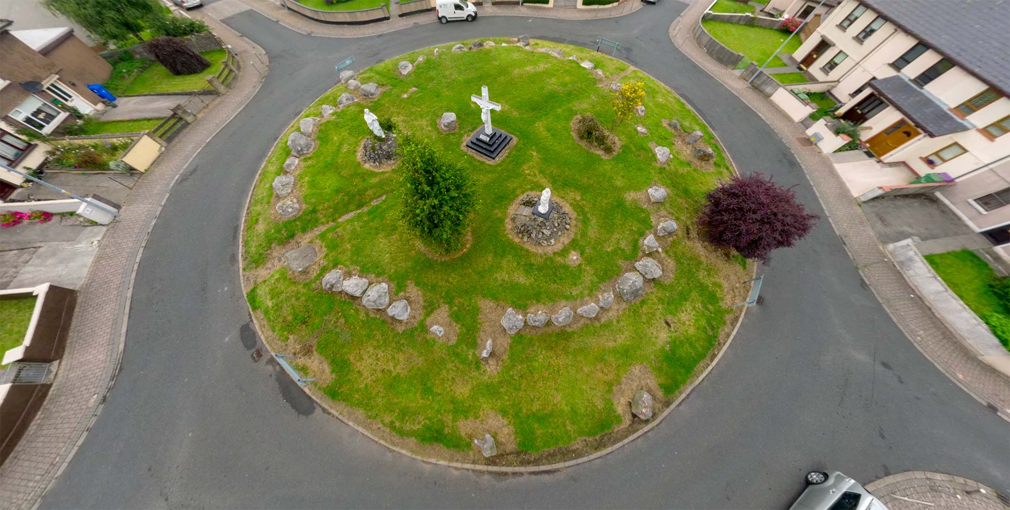
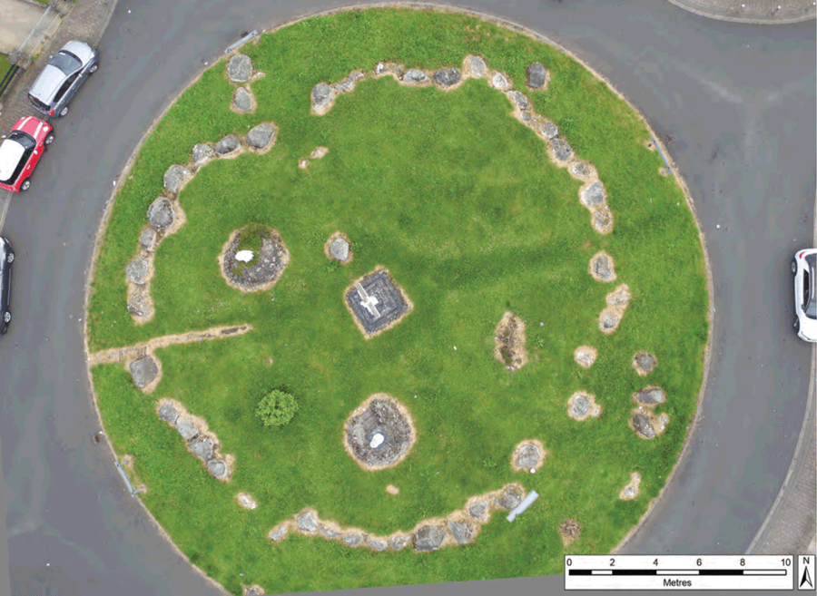
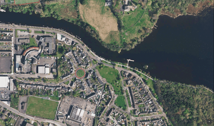
When Sligo antiquarian Wood-Martin wrote in 1887 that the monument in Abbeyquarter North was “within hearing of the hum of the now busy town,” the stones were then still well removed from the city’s population, on a raised earthen platform with a clear view to the Garavogue River 80 m (260 ft) away, surrounded by gently rolling green hills. Today, however, the Abbeyquarter Stones occupy the center of Ireland’s only traffic circle containing a prehistoric monument. Constructed as a home for the dead, it now serves as a roundabout leading to scores of homes for the living.
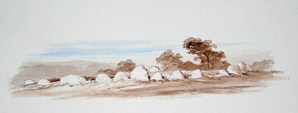
Drawing by William Wakeman, 1879
The monument was sketched in 1879 by William Wakeman, who accompanied Wood-Martin on his explorations of the megalithic monuments in the Sligo area.2 The antiquarian’s Sligo estate, Cleveragh. was about a kilometer south-east of the Abbeyquarter circle. The house was demolished in 1999; the estate is now the location of a community garden. But the only gardens visible from the Abbeyquarter stones are the carefully manicured lawns of the 1940s-era Garavogue Villas, whose neatly-kept homes are but 15 m (49 ft) away from the ancient stones, as may be noted in the aerial virtual-reality views above.
Abbeyquarter: A stone circle or a fort?
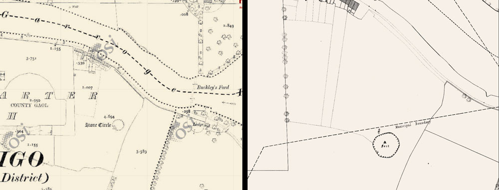
The monument is one of Sligo’s oldest structures, dating back nearly five and a half millennia.3 It goes by a number of names, being variously considered a stone circle, a passage tomb, a dolmen,4 or even a fort, as depicted in the illustration from different Ordnance Survey maps, left. Google also labels the monument as “the fort,” and provides its own virtual-reality view. Locally, it was traditionally referred to as the Garavogue Fairy Fort, alluding to accounts of the supernatural—stories to be explored in the “Folklore” section below.
The Archaeology
“[Abbeyquarter’s] position in the landscape suggests an intentional siting at a juncture and crossing point into a sacred landscape.” (Sam Moore) 5

Sligo Town Seal, 1775
The most renowned of the Irish passage tombs, such as those at Newgrange and Loughcrew, feature a passage—often decorated with rock art—tunneling through a large covering mound and ending in a central cruciform burial chamber. However the passage tombs of this part of Co. Sligo, the Cüil Irra peninsula, are of a more primitive construction.6 The Abbeyquarter monument, like those within the sprawling Carrowmore Megalithic Cemetery 4.5 km (2.8 mi) to the south-west, may perhaps most accurately be described using Stefan Bergh’s term: “boulder circles.”7 The Abbeyquarter boulder circle most closely resembles Carrowmore’s Circle 27.
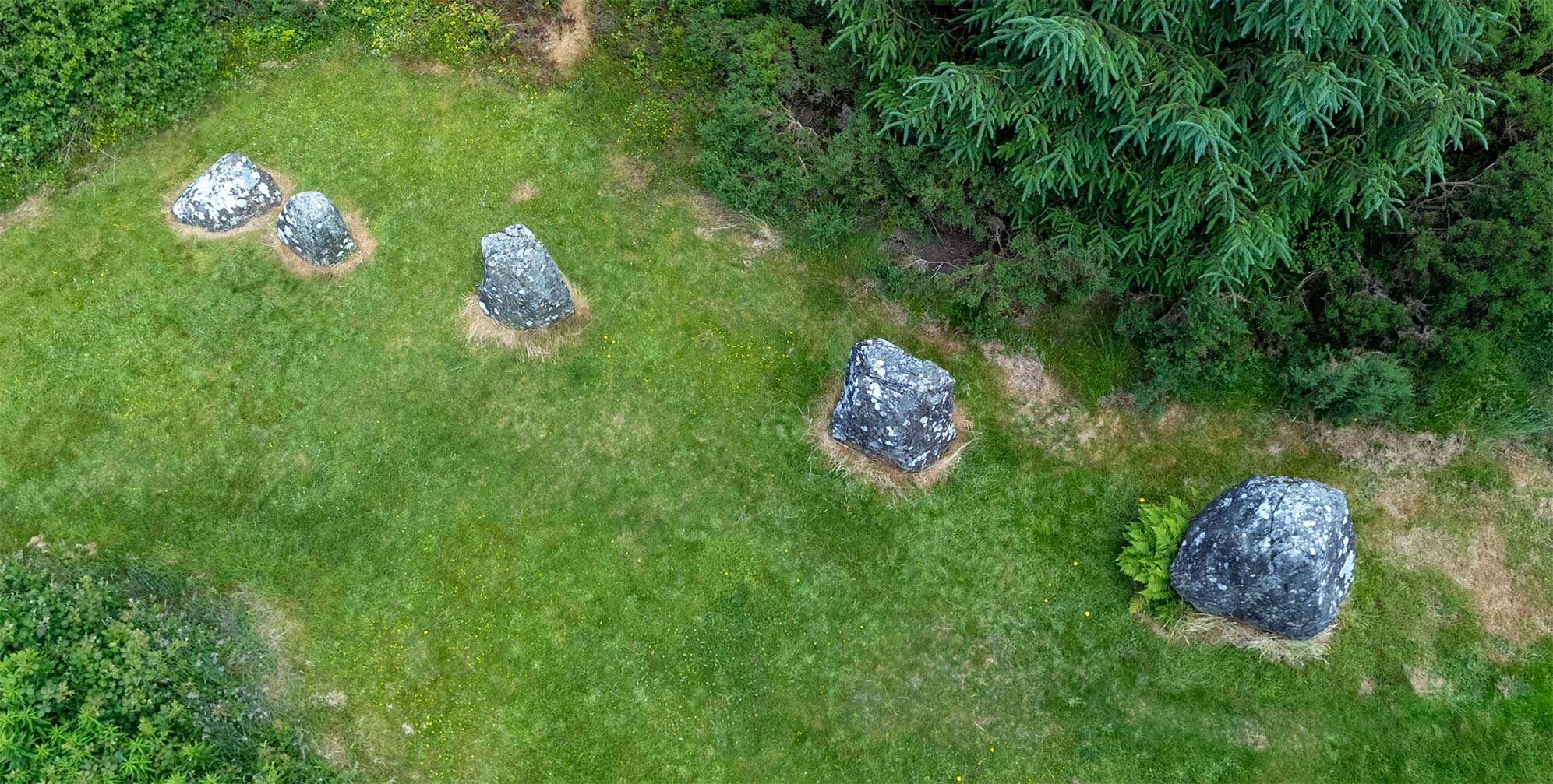
Boulder circles do have a burial chamber, or cist, at or near the center of the circle. But these are of a simple construction, perhaps only rudely cruciform. There is no mound covering the burial; it was designed to be seen from the outside. The Abbeyquarter burial chamber today consists of a single boulder, although there were at least two stones present when Wood-Martin excavated the site in 1885 or 1886. The 45 boulders in the circle today are all that remain of the (estimated) 55 that originally defined the monument.8 The diameter of the boulder circle is 23 m (75 ft). The animation captioned “Changes,” below left, demonstrates the alterations in the circle over time. There are two stones standing separately in the northern part of the circle, which together with two others in the southern part (visible in the aerial view of the “Changes” graphic) may be all that remain of a possible inner circle, the symbolic meaning of which is considered below.9
These tombs are designed so that the burial chamber, on its raised platform, would be noted from outside the circle of boulders. The chamber is spatially connected to the circle by the vertical and horizontal distance between the two. Martin Byrne describes this as a connection between the world of the living and the world of the dead: “physical constructs which represent a non-physical space, using the most enduring medium, stone.”10
Excavating into the cist, which he considered but a part of a larger original burial chamber, Wood-Martin described his finds:
“… traces of the flooring of the cist were discovered, and on it were some bones, of which the greater portion were calcined; the interment had been greatly disturbed… The miscellaneous ‘finds’…were mixed up together in inextricable confusion, and lay but a few inches beneath the surface of the soil; they consisted of 1¾ lbs. of calcined bones, seemingly all human, but in a very fragmentary state, 2½ oz. of uncalcined human bones, three molars, and one incisor tooth of a young individual, the tooth of a goat, and another probably of a dog, also the bones of a goat or sheep.” 11
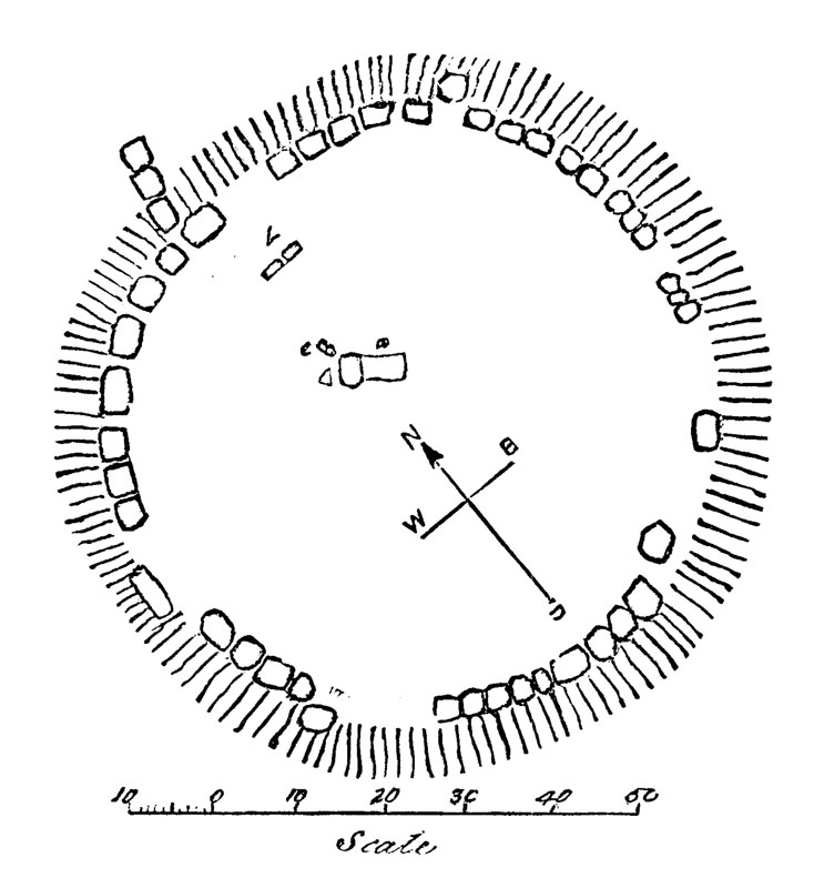
Wood-Martin’s 1887 Plan of the Circle
None of these items—human or otherwise—were properly cataloged and archived, and thus none were subjected to modern radiocarbon dating techniques. As Wood-Martin and others after him have acknowledged, it is likely that the remains discovered represent a long timeline of deposits in the tomb, extending into the Iron Age.
Of the some 1,450 megalithic monuments in Ireland, around 15% (approx. 220) are to found in Co. Sligo, which occupies only 2.5% of the landmass. Many of these (40%) are passage tombs of one type or another; four out of ten Irish passage tombs are found in Sligo.12 With such a representation within the passage tomb roster, it is not surprising that two of the most vexing controversies of Irish archaeology have focused upon the monuments of Sligo’s Cüil Irra area.
One controversy was launched by Swedish archaeologist Göran Burenhult, who is best known for his excavation (1977–1982) of the central Carrowmore monument known as Listoghil (Carrowmore #51).13 Listoghil’s burial cist, a structure which resembles a large portal tomb, may be seen in this VR view made during its excavation. Burenhult announced a timeline for Carrowmore that placed the passage tomb group much farther into the past than any other such site in Ireland. He based his startling theory upon his analysis of radiocarbon dates derived from burnt materials found underneath the stones of Carrowmore 3. Believing this deposit to be from the era of the tomb’s construction, he proposed that the monument could date from as early as 4771 BCE, predating the large passage tombs of the Boyne Valley by at least 700 years. This, Burenhult proposed, “suggested an origin of megalithic practices in the Mesolithic period.”14
Changes.
Click to see the Abbeyquarter stones overlaid with Wood-Martin's diagram.
In the decades following Burenhult’s discoveries other archaeologists rejected his proposed timeline, which would have had the hunter-gatherer populations of the Mesolithic initiating the burial practices of later Neolithic farming communities. They instead suggested that the burnt material upon which Burenhult based his analysis was deposited underneath the footprint of the tomb by an earlier Mesolithic culture; a population long predating the construction of the Carrowmore circles. More recent studies (2013), using dates derived from materials known to have been used in the monuments, indicated that the tombs likely were not used before c. 3750 BCE, which would still make them among the first passage tombs in Ireland. While Burenhult’s dates remain controversial, recent discoveries may make an earlier date for complex tombs more likely.
The revelation that large stone structures in Turkey at Göbekli Tepe and elsewhere date to before the Neolithic provides a new, and still unfolding perspective. As the authors of the 2021 book The Dawn of Everything wrote, “Clearly foragers didn’t shuffle backstage at the close of the last Ice Age, waiting in the wings for some group of Neolithic farmers to reopen the theatre of history.”15
The second question that has vexed archaeologists over the years concerns how the changes in the construction of the Irish passage tombs evolved. For several generations most archaeologists presumed that the Neolithic builders began on Ireland’s east, with the elaborate passage tombs of the Boyne Valley: Newgrange, Dowth, and Knowth.
Click for an animation showing how the Abbeyquarter stones may have appeared in the Neolithic.
What followed, according to the accepted wisdom from the 1930s through the 1970s, was a “sequence of degeneration,”16 with the building, successively, of the less complex monuments at Loughcrew, and then Carrowkeel, followed by the final, and simplest constructions of the Cüil Irra boulder circles found at Carrowmore and Abbeyquarter. While Burenhult’s theory of pre-Neolithic passage tomb culture may now be “jettisoned,”17 the archaeologist himself (2019) still maintains its central premise. But what cannot be denied Burenhult is that his discoveries helped to reverse the traditional understanding of the direction in which the culture of passage tomb building progressed across Ireland. It is now generally accepted that the complex structures on the Boyne are the culmination of a long cultural tradition of passage tomb construction.
The Folklore
Although there are any number of instances in Ireland where taboos regarding the removal of certain stones—or trees—from ancient sites served as a protective force that help ensure the monument’s survival, this was not always the case. According to George Petrie, who in 1837 lamented the loss of many of the Carrowmore boulder circles:
“… the destruction going on daily is horrible, and if I did not work now it would be too late to preserve a memorial of them in a short time. The peasantry, generally, have no reluctance to destroy them; on the contrary, are glad to get permission to clear the ground of them.” 18
This destruction was also happening in the developing regional center of Sligo Town, where property available for development would be more limited than in the countryside. Another likely Neolithic boulder circle, once known as the Sligo Stones, stood unmolested for five thousand years at a spot about a kilometer west of the Abbeyquarter circle. They were last mentioned in 1783, and then removed without a trace from their spot in a lane near the present Presbyterian Church, built in 1828. The Sligo Stones may be those once depicted on the town seal (above, right).19

Garden Gnomes keep watch near the Abbeyquarter stones.
While there are no stories of ill fortune coming to those who destroyed the Sligo Stones, there are a number of folklore accounts detailing mysterious circumstances attached to the Abbeyquarter circle, which, after all, is also known as the Garavogue Fairy Fort. One story, found online, concerns a little girl of four who, looking for her mother, wandered out of the house late one night. She became lost, and soon found herself in the Garavogue Fairy Fort. “All of a sudden ‘Little People’ appeared around her. They were friendly and escorted her to a nearby house and knocked on the door. When her mother came out the little girl tried to introduce her new found friends, but they were nowhere to be seen.”20
Another account, recorded on a 2022 radio program by local resident Kathleen Cadman, recalls a story she heard as a child:
“…we would be told about people who actually went up on that fort at night, to go from one house down to the next house to visit, that on several locations they actually could not get off the fort. No matter how hard they tried and this would have been at night time. And even up here in Magheraboy, where I live, I remember being told by Mr. Devins, who is long gone now, that there’s some of the fields up there, and he himself was included in this, that he tried to get out of the field, and no matter how he tried he could not get out of the field and he told us that story himself, so there is something there.” 21
While the Abbeyquarter Passage Tomb has survived until today, it has not made it into the present day unmolested. Wood-Martin’s primitive 19th-century excavation aside, the monument was to undergo a further assault in 1950 that would prove disconcerting to some, while comforting to others. In that year Pope Pius XII proclaimed the Dogma of the Assumption. The local parish priest, a Father Collins, would have preferred, according to some sources, to have the entire circle destroyed to signal his disdain for pagan superstitions.22 But instead he set his gaze upon a hawthorn tree near its center. It seems that the tree was occupying his favored spot for the placement of the central figure in the three-statue Calvary scene envisioned to top the boulder circle in celebration of the Holy year that followed the Pope’s proclamation.
The hawthorn tree, of course, is greatly favored by the fairies, and doubly so when located within an ancient burial site. So naturally the local workmen balked when directed to remove the tree. Ultimately the priest prevailed, but, as Kathleen Cadman tells the story, things went very badly afterwards:
“…there was a hawthorn tree in the center of the fort, and we would play around in it and everything. But nobody dare would touch it or anything. [When] the priest said that this tree had to be taken down…the men refused, and the priest went ahead anyway, and said, ‘No, that tree has got to come down.’ So the tree was taken down. Now the story begins there of what I have to tell. In 1953, which is coming up to almost 70 years [ago], three young men were tragically killed, from Garavogue, in Sligo. The first one would have been my father, which was Morris Langon. The second was a man, he was outside where St. Anne’s Road is; he was killed tragically by a lorry. And the third man was a very good swimmer, and he also lived in Garavogue. So three men were tragically killed with different accidents when that tree was cut down. Now the people firmly believe that this was due to the tree being cut down.” 23

A Monumental Dialogue
The hawthorn tree was not to be the only casualty of the Holy Year statuary. As may be noted in our animation (“Changes,” above) one stone of the Abbeyquarter burial cist was removed to accommodate the base of the Crucifixion statue. The addition of the Calvary statuary to the passage tomb, fairies aside, remains controversial today. Some believe that the Christian symbols triumphantly crowning the Neolithic monument are a desecration of an ancient burial site and function as a cultural appropriation, an affront to an unknown and unknowable prehistoric belief system. Such an attitude may be reflected in an imagined dialogue between the monuments (right), from the Monumental Ireland Facebook page, where the comments continue the dialogue. Others, however, have a more sanguine view of the Calvary statues, and feel, as archaeologist Sam Moore noted, that they “create another layer of meaning for the monument.”24 As one commentator wrote on Facebook: “I don’t mind the religious paraphernalia in it, at this stage that’s part of its story, the main thing is that it was kept and is now maintained from further damage.”
Landscapes Real and Metaphorical
While Abbeyquarter is an outlier, defining the space leading to Carrowmore, the most dramatic Neolithic monuments in the Cüil Irra landscape are two that, on a clear day, would be visible from the Abbeyquarter circle. One Neolithic geomarker on the skyline, visible in our highest aerial VR view of Abbeyquarter, are the twin monuments on the peaks of Carns Hill some 1.7 km (1.1 mi) to the southeast. Far more impressive is the summit of Knocknarea, where sits the massive—and never excavated—cairn known in legend as Queen Maeve’s grave, 7.5 km (4.7 mi) southwest of Abbeyquarter. A panoramic view of the twin Sligo landmarks of Ben Bulben and Knocknarea from may be seen here.
Who was the first person to be singled out, so long ago, for their bones to lie in the Abbeyquarter boulder circle? While it is enticing to think that we can identify a specific individual buried in one of these tombs, such as Queen Maeve, the effort is ultimately illusory. Since we know that only a very small percentage of the population was buried at all, what made those few interred in the cist of a boulder circle so special within the population? Were they legendary kings, priests, military heroes, or others with great significance to the community? Or were they instead, as was found common in Paleolithic tombs, people born with physical differences such as dwarfism or a spinal deformity.25
The Garavogue River is only 4 km (2.5 mi) long, from its source at Lough Gill to the rapids at Sligo Bay. But since at least the Mesolithic it has served as a rich resource, providing an abundance of shellfish for the peoples inhabiting the area. This is demonstrated by the many shell middens—the remnants of prehistoric feasts—reported found by the “cart loads” during early construction in town.26 In fact, “Sligo” is the anglicization of the Irish Sligeach, meaning “abounding in shells.” In his excavations at Carrowmore Burenhult uncovered evidence under some of the tombs that suggested the monument builders (or their ancestors) relied upon a diet of shellfish. This view is now contradicted by more recent analyses of the human remains.27
It is no wonder, then, that the gently rising lands south of the Garavogue would have been a desirable territory for a group of Mesolithic hunter-gatherers, or a later Neolithic community of agriculturalists. The Abbeyquarter Passage Tomb has a direct sightline to the narrowest point of the Garavogue River 80 m (260 ft) away, where the river suddenly constricts from approx. 200 m (219 yd) to approx. 42 m (46 yd) in width.
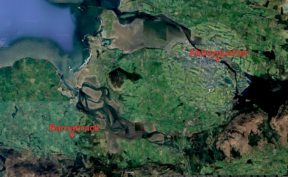
Abbeyquarter and Barnabrack Boulder Circles
Up until recently this was called Buckley’s Ford, as may be noted on the 25” 1916 Ordnance Survey map, above left. The geologic conditions that made this location a convenient spot to cross the Garavogue may have differed in the Neolithic, but it remains likely that the point where the river abruptly narrows always had significance in the landscape. As a larger-than-normal outlier of the vast megalithic cemetery at Carrowmore, 4.5 km (2.8 mi) to the southwest,28 Abbeyquarter may have served as a spiritual threshold for the community, and along with the river, geographically and symbolically “wrapping the landscape.” As Sam Moore suggested,
“Once the Garavogue was crossed at Buckley’s ford, or whatever type of crossing that existed during the Neolithic, Abbeyquarter North acted as a symbolic marker that may have aided movement towards the physical and symbolic heart of Cuil Irra at Carrowmore.” 29
….
“The performance of complex rites of transition at thresholds that cross boundary places may have served to protect people from potential threat from super-natural entities, from possible pollution that may emanate from these liminal zones which could also contaminate the temporal sphere of everyday life.” 30
The Abbeyquarter tomb, exceptional due to its nearly-miraculous survival—mostly intact—into the 21st century, was not alone in its “symbolic marker” role. Just as exceptional due to its isolation31 located 11.7 km (7.3 mi) to the southwest, on a low hill overlooking the village of Beltra, are found the remnants of the Barnabrack boulder circle, another larger-than-normal outlier of the Carrowkeel group, located at at the narrowest point between the Ox Mountains and the sea. Abbeyquarter and Barnabrack are both positioned at clear points of passage into the Cüil Irra region. The position of the two monuments may be noted in the map illustration, above, left.32 As Stefan Bergh observed, “Both monuments are the first to be observed when approaching the Cüil Irra region, and reflect a spatial territoriality not traced among the other boulder circle monuments.”33
The Abbeyquarter circle itself can be seen, both metaphorically and physically, to represent dual zones of transition. If indeed the four inner stones at Abbeyquarter once formed part of a second, innermost circle, than the act of walking from outside, through the initial boulder circle, and then finally into the ultimate ring of stones, may have represented an entry to realm of the highest sanctity or at least the place farthest removed from the realm of the living. We can only speculate as to the nature of such a ceremony in the Neolithic. Similarly, archaeologists in the distant future may ponder a spiritual explanation for the evidence that motor vehicles once circled around an ancient stone circle.
As Stefan Bergh observed:
“A passing Neolithic man would have been familiar with, and active within, the symbolic messages of design and location which were incorporated into the monuments. He knew how to read, interpret and react to these messages.
Today, when we, about 170 generations later, assume the position of the passer-by and receiver of these messages, we must be aware of the fact that along with a time difference, follows considerable limitations in our potential to understand.” 34
Click here to see all the notes from this page.
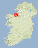
Abbeyquarter Stone Circle, Co. Sligo
Nearest Town: Sligo
Latitude: 54° 16′ 11.7546″ N
Longitude: 8° 27′ 39.1746″ W