15 Oct Queen Maeve’s Cairn
(Meascán Mhéabha)
“The emergence of monuments indicates that individuals were no longer adapting themselves to the landscape but were making the landscape adapt to them. This process should not be seen as ‘taming the wild’ but as an adaptation of the language of the landscape, making it into a tool of influence. The building of megalithic monuments in the Neolithic changed the landscape in a way never seen before.”
Stefan Bergh 2002 1
“It’s funny looking back on the early days; Knocknarea was just a place you went up with a six-pack of Smithwicks and you sat on the summit and watched the sunset and you didn’t really link it to Carrowmore. The closer and closer I worked on it, I realised that Knocknarea is probably one of the main reasons why people came here in the first place, because it is such a significant hill. That it is a landmark. We still identify it with Maeve and it’s still a sign of identity for the whole region.”
Stefan Bergh, 2015 2

Click the image above to enter the virtual-reality tour.
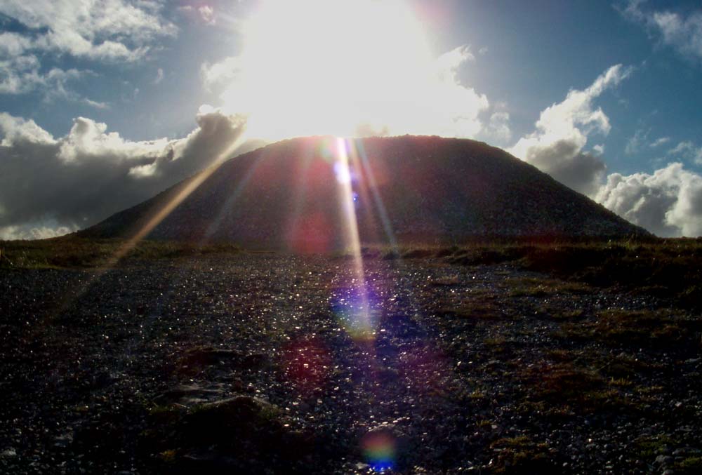
Meascán Mhéabha (Queen Maeve’s Cairn) rises like a pale-grey crown above the flat-topped summit of Knocknarea, its vast mass of stone turning the entire mountain into a single, commanding monument over Sligo Bay. The cairn is intact; never excavated, its internal structures remain a mystery. It is likely to be about 5000 years old, the same age as the excavated Boyne Valley passage tombs at Newgrange, Knowth, and Dowth. From the fertile grasslands of Cúil Iorra to the distant Ballygawley and Ox Mountains, the cairn is both beacon and boundary marker, tying together a web of tombs, caves, and stories that have accumulated for at least five millennia.
Knocknarea is a steep-sided limestone hill, 327 m (1073 ft) high, standing almost island-like at the western end of the Cúil Irra peninsula, surrounded on three sides by sea and tidal inlets. The flattish summit is capped by Meascán Mhéabha, a massive, flat-topped limestone mound roughly 60 m (197 ft.) in diameter and about 10 m (33 ft.) high, probably containing an unexcavated Neolithic passage tomb. One estimate suggests that some 30,000 tons of stone were quarried nearby to build it, leaving a great hollow on the summit a few hundred meters to the north where the builders cut deeply into the bedrock.3 A 3D model of the cairn may be seen here.
Seen from below, the cairn’s silhouette echoes the squat bulk of the mountain itself, a miniature, man-made version of the larger landform. Up close, its apparently simple outline gives way to complexity: protruding gneiss kerbstones around the base, a low earthen bank that swings outward to encompass smaller cairns and marker stones, and five low stone mounds abutting its flanks. Early drawings from the 18th century show almost the same truncated-cone profile as today, suggesting the cairn’s form has remained remarkably stable for at least three centuries.4

Meascán Mhéabha has never been opened. Its internal passage and chambers, if they exist, have remained sealed since prehistory. Unlike the more celebrated Newgrange, no archaeologist has cut into its core, and it escaped the depredations of 18th- and 19th‑century treasure hunters, such as local landlord Roger Chambers Walker, who looted many of its smaller neighbors and the Carrowmore tombs on the plain below. Walker, in fact, had aspirations to plunder the cairn: “In a letter of 1836 to Thomas Larcom of the Ordnance Survey, he wrote that “… perhaps the Tumulus of Queen Maud may be ransacked…” 5
Today the cairn is widely known as Queen Maeve’s Grave, a name that folds Iron Age legend over a Neolithic structure already two thousand years old when Maeve’s stories were first told. Maeve, the formidable queen of Connacht at Rathcroghan in Roscommon, is most famous from the Táin Bó Cúailnge, where she launches war on Ulster to seize the Brown Bull of Cooley. Later tradition insists that such a woman could be interred nowhere less than the greatest of Connacht’s tombs, so she is said to stand within the hidden chamber of Knocknarea’s cairn, buried upright in her armor and facing her ancient enemies in Ulster. 6
Gabrial Beranger (1779) noted:
“These legendary burial practices echo the Egyptian customs of burying the kings within the pyramids – in death, they act as symbolic and spiritual guardians of the landscape they once ruled.” 7
Whoever may be entombed on Knocknarea, one thing is clear (from a mythological point of view): “Such immense labour as went into the making of this monument would only have been undertaken to perpetuate the memory of some person or event of the most outstanding importance.” 8
")
However, it should be noted here that from an archaeological point of view Neolithic passage tombs such as Meascán Mhéabha were monumental communal burial spaces and not intended for any specific individual.
Behind the warrior queen stands an older figure: Maeve as goddess, the personification of Connacht itself. Her name can be translated as “the intoxicating one,” and medieval texts and folklore suggest that kings married Maeve in inauguration rituals, often on ancient mounds like Listoghil at Carrowmore or the cairn at Heapstown, renewing a sacred bond between ruler, land, and the Divine Feminine. Using these —neither historic nor scientific—sources, Miosgán Meadhbha is not simply a grave; it is a place where kings entered into a formal union with the province, under the gaze of a goddess whose body is the landscape.
Maeve’s reputation extended to her amorous appetite: “As well as being the paramour of the prodigiously virile hero Ferghus mac Reich and others, she is said to have claimed that ‘never was she without one man in the shadow of another…’” 9 In some quarters, Maeve is a badass superhero.
Nuala Ní Dhomhnaill, in the first verse of her 1981 poem Labhrann Medb (“Medb Speaks”), gives the queen quite a different voice:
“War I declare from now
on all the men of Ireland
on all the corner-boys
lying curled in children’s cradles
their willies worthless
wanting no woman
all macho boasting
last night they bedded
a Grecian princess
a terrible war I will declare.” 10
Place names add further layers to the mythic geography. Knocknarea (Cnoc na Riabh on modern placename records) has been variously interpreted as “hill of the stripes,” “hill of the executions,” “hill of the kings,” and even “hill of the moon.” Together these names gesture toward a hill long understood as a seat of judgment, royal power, and celestial watching-place, rather than a neutral landform.
Folklore has made use of the vast stage of Knocknarea and Meascán Mhéabha in other stories, some of them captured in the Schools’ Collection (folklore compiled by schoolchildren in the 1930s). One such story has Fionn Mac Cumhaill and three of his Fianna warriors competing to see who could throw “finger stones” off Knocknarea the furthest.
As Marion Dowd recounts the tale, “They each threw a boulder, three of which fell on end and remained standing upright, the fourth landed on top of the other three.” Where the stones landed they formed what was described as a “Druid’s Altar.” Dowd has identified the Cloghcor Portal Tomb as the most likely candidate for the stones described in this folktale, as it has two massive upright stones and a collapsed capstone.11
You can see this monument in a panoramic view, with Knocknarea in the distance, by clicking on the image to the right.

.")
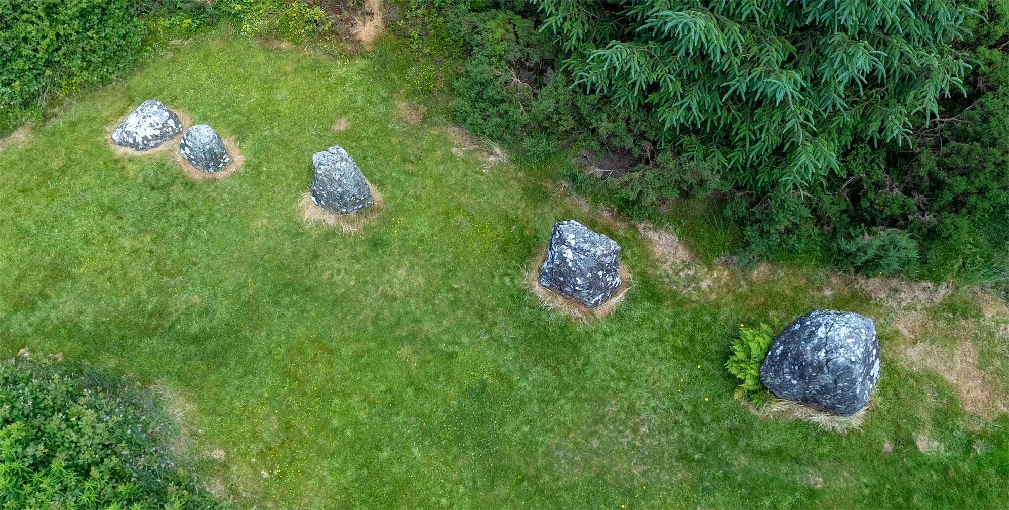
Beneath these later stories lies a Neolithic center of striking scale and sophistication. Queen Maeve’s Cairn is part of the Irish passage tomb tradition, probably built between about 3500 and 3200 BCE, roughly contemporary with Newgrange, Knowth, and Dowth in the Boyne Valley. On Knocknarea’s summit, at least five smaller tombs and cairns form a roughly north–south line, while a ruined boulder circle lies on a lower eastern shelf; all of them seem to participate in a planned ceremonial zone, with Maeve’s Cairn as the dominant focus.
Around the cairn itself, archaeologist Stefan Bergh identified a low platform or bank beneath the stones, and a subtle earthen ring that bends outward to encircle not only the cairn but also five smaller stone mounds and two large marker boulders on a north–south axis.
The northern “marker stone” is a prone slab; the southern stone is a glacial erratic, and together they bisect the monument along a line that also passes through several of the satellite tombs. At the base of the cairn, a buried kerb of gneiss boulders—glacial erratics imported naturally from the Ballygawley Mountains—once formed a retaining ring, much like the kerbs at Newgrange and other classic passage tombs.12
The mountain itself was heavily used in the Neolithic. On the summit and upper southern slopes, survey and excavation have revealed around thirty hut or house sites and roughly 2.5 km (1.5 mi) of stone walls and banks, forming a boundary along the accessible south and east edges of the plateau. These banks are at about 100-150 meters (328-492 ft.) from the actual summit, and they cross the whole eastern side of the mountain. As Stefan Bergh wrote:
“By enclosing the mountainside with extensive banks, the ritual monuments on the summit were given a physical and symbolic definition. The ritual space of the mountain was defined on the ground.” 13
Bergh compares Meascán Mhéabha to a cathedral in this video.
The huts contained thousands of pieces of worked chert, and there is a Neolithic chert quarry on Knocknarea’s eastern flank, suggesting episodes of residence or intensive activity associated with visits to the tombs above. An enormous quarry pit close to the summit marks the source of limestone for the cairn itself, a “backstage” working hollow hidden just west of the ceremonial crest.14
Viewed from below, the cairn is stitched into a wider ritual topography. It stands at the western end of an east–west line noted by researchers that links Knocknarea, Carrowmore, Sliabh Dá Én, Sheebeg, Loughcrew, Tara and the Hill of Howth.

From Shreeloga Hill in Co. Mayo, observers at the equinox can watch the sun rise over Knocknarea; from the cairn called Shee Lugh on Moytura (on the opposite shore of Lough Arrow), the summer solstice sun sets behind the mountain. Other large cairn‑topped hills—Knocknashee, Muckelty, Sheemor—lie within the same visual theatre, their summits intervisible with Maeve’s Cairn in clear weather.15
From the top of Knocknarea itself the view is vast. The cairn commands a horizon stretching 60–70 km (37-44 mi) in all directions: Benbulben’s plateau to the north, the Ballygawley and Ox Mountains with their own cairns, the Carrowkeel and Kesh Corran complexes to the south‑east, and the sea to west and north. The cairn thus operates both as focal point and as node in an interlinked network of monuments, skies, and sea‑routes.
The Neolithic story of Knocknarea does not end on the summit. Along the western and northern cliffs of the mountain, at least twenty‑seven caves and fissures lead into the limestone, many of them clustered in terraces on the north‑west face. For a long time these were treated as geological curiosities, separate from the grand architecture above. Recent work has shown that they, too, played a role in the mountain’s ritual life.
In 2013, a small cluster of human bones—thirteen fragments in all—was recovered from one of these caves, known as Knocknarea Cave K, at about 235 m (771 ft.) above sea level. The bones, representing at least one adult and one child, were unburnt and heavily weathered: radiocarbon dating places both individuals in the Middle Neolithic, between about 3635 and 3010 BCE, broadly contemporary with construction and use of the summit tombs. Nearby, an adult cranial fragment from cave C, some 50 m (164 ft.) away, has almost identical dates, suggesting that more than one cave on the north‑west face hosted Neolithic human remains.16
The assemblages are tiny and tantalizing. There is no sign of complete burials: only small, easily overlooked elements survive—vertebrae, rib fragments, foot phalanges, cranial splinters—many coated in calcite from long exposure on the cave floor. No cut marks or burning show on the bones; there are no grave goods, nor any clear grave cuts in the cave sediments. Taken together, the pattern fits a different kind of mortuary practice: excarnation.17
, pp. 1-16.)")

Archaeologists Marion Dowd and colleagues argue that bodies may have been placed whole in these cramped passages, left for months to decompose in constant cave temperatures, protected from scavengers, and then revisited when flesh was gone. Larger bones could then be gathered up and carried elsewhere—perhaps to passage tombs such as Miosgán Meadhbha—for final deposition, leaving behind only small, scattered fragments missed in the dark. The narrow entrances and twisting passages of the caves would have forced mourners into intimate, physically demanding contact with the dead, a stark contrast to the broad, sky‑exposed platform of the summit cairn.
“…spending time inside confined dark narrow caves, in close proximity to decomposing human cadavers, would have greatly precipitated feelings of discomfort and anxiety, while also heightening physical and sensory awareness. These were powerful encounters.” 18
If this interpretation is correct, Knocknarea’s Neolithic funerary landscape becomes a tightly integrated whole. Caves on the secluded western face functioned as processing places, liminal chambers where corpses were transformed into ancestral bone; huts and enclosures along the southern shoulders hosted living communities and craft activities, including the working of chert tools that may have played a role in these rites. On the summit, the great cairn and its satellites received carefully selected remains, visible for miles and aligned with distant monuments and the movements of the sun.
As Stefan Bergh noted:
“Miosgån Meadhbha represents an investment, measured in cairn-volume, c. 70 times larger than and any “ordinary” cairn in the region.” 19
In modern decades the cairn has drawn a different kind of pilgrimage. Pathways from the eastern car parks carry hundreds of walkers up the slopes on fine days, and a once seamless Neolithic surface is increasingly scarred by erosion, cairn-slip, and informal stone‑stacking. Archaeologists and heritage agencies warn that climbing and moving stones may destabilize the hidden tomb within; even local folklore insists it is bad luck to damage such monuments, and that disrespect can bring a curse.

In times past, local tradition held that each visitor to the mountaintop should add their own stone to the cairn. Today, disregarding the signs that warn against climbing the cairn, visitors have created a small cairn of their own atop Meascán Mhéabha. This is visible within the first two nodes of our virtual-reality tour. Even more disrespectful are those who feel the need to take one of the stones away with them.20
Astride the Atlantic, beneath weather that can erase the cairn in cloud or blaze it bright at sunset, Meascán Mhéabha stands as both archaeological puzzle and mythic anchor: a sealed Neolithic chamber wrapped in Iron Age legend, watched over by a queen who may never have lain there, on a mountain that was once as sacred to farmers and storytellers as any temple.
William Butler Yeats wrote (1903):
“The wind has bundled up the clouds high over Knocknarea,
And thrown the thunder on the stones for all that Maeve can say.
Angers that are like noisy clouds have set our hearts abeat;
But we have all bent low and low and kissed the quiet feet
Of Cathleen, the daughter of Houlihan.” 21
Click here to see all the notes from this page.
Knocknarea South, Co. Sligo
Nearest Town: Sligo
Nearest Village: Strandhill
Latitude: 54° 15′ 31.98″ N
Longitude: 8° 34′ 23.67″ W